ザ・サンダーボルツ勝手連 [Wilpena Pound ウィルペナ・パウンド]
[Wilpena Pound ウィルペナ・パウンド]

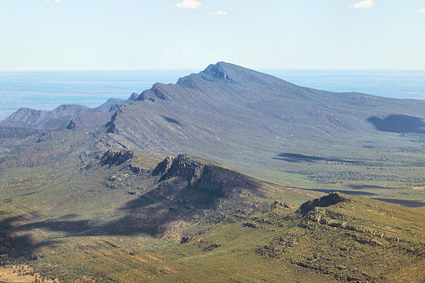
Wilpena Pound. Flinders Range, South Australia.
ウィルペナ・パウンド。 フリンダース山脈、南オーストラリア。
――――――――
Mar 31, 2008
フリンダース山脈には、オーストラリアで最も珍しい地層がいくつか含まれています。 巨大な電気アークの紛れもない兆候です。
以前のいくつかの「今日の写真」の記事で、オーストラリア大陸の地史を検討したところ、多くの地層の外観と構造にいくつかの不一致があることがわかりました。
〈https://takaakifukatsu.hatenablog.jp/entry/2021/04/23/182825〉
有名な「レッドセンター」は、ウルル、カタジュタ、その他のモノリシックな石の塔が比較的平坦な風景の上に孤立した壮大さで立っているため、特に注目に値します。
〈https://takaakifukatsu.hatenablog.jp/entry/2021/05/04/073647〉
フリンダース山脈は、砂岩と珪岩の険しい露頭で、アデレードの北約250キロメートルから始まり、800キロメートルにわたって伸びています。
〈https://en.wikipedia.org/wiki/Flinders_Ranges〉
山々は大きく折りたたまれて割れており、いくつかの深い峡谷が山を貫いています。
この範囲で最も珍しい特徴の1つは、ウィルペナ・パウンドです、83平方キロメートルをカバーする石の自然の円形劇場で、内部の寸法は11キロメートル×8キロメートルです。
フリンダース山脈の従来の見方では、6億5000万年以上前に、現在は絶滅した海の堆積物として形成されています。
地球の動きが材料を上向きに押し上げてドーム型にし、その後、風と水による自然の侵食過程で摩耗しました。
何千年もの間、周囲の山頂は減少し、丘と谷は大砂漠のほこりと砂に消えていきました。
標準的な理論を運用すると、ウィルペナ・パウンドは流星の残骸であるように見えますが、全体の形状に影響を与え、層序構成はその考えを支持していません。
〈http://livingtravel.com/australia/southaustralia/flinders/WilpenaPoundGeneralViews/WilpenaPoundW_PB090957.jpg〉
しかし、過去に指摘されたように、侵食は現代の地質学が主張する変化に対する包括的な力を持っていません。
〈https://takaakifukatsu.hatenablog.jp/entry/2021/04/25/093531〉
ニューメキシコ州シップロックに関する今日の写真では、二重尾根の断層、共通の中心から伸びる湾曲した峡谷、正弦波のうねりが刻まれた鋭い尾根は、すべて、プラズマナイフのように地形に切り込む大陸規模の稲妻の残骸であると言われていました。
〈https://takaakifukatsu.hatenablog.jp/entry/2021/09/26/005623〉
ウィルペナ・パウンドの中にはエデアウイー・ゴージがあります。
〈https://www.nationalgeographic.com/photography〉
〈https://bushwalk.com/forum/viewtopic.php?t=2311〉
ガラス化の顕著な例はそこにあります、峡谷は砂岩の表土の下に埋められた淡黄色のガラスのシートを明らかにしているからです。
ガラスは非常に純粋で、リビア国境近くのグレート・サンド・シーにあるエジプトの「砂漠のガラス」のように、土壌やミネラル含有物が混ざっていません。
両方のガラス堆積物には、イリジウムの暗い塊とクリストバライトの小さな泡も含まれています―
ガラスが作成されたときに非常に高温のアプリケーションを指す特徴です。
砂漠のガラスは、地球軌道から撮影された画像を分析することによって最近発見されたケビラと呼ばれる巨大なクレーターに関連付けられています。
この幅32キロメートルの窪みは、小惑星衝突の古代遺跡であると言われていますが、クレーターの兆候はほとんどなく、その中心には複数の鋭いピークがあります。
そのような属性は他の場所で議論されており、砂を溶融ガラスに融合し、次に広い領域にわたってチャンク(塊まり)を外側に吹き飛ばす電気アークからのものであると理論付けられています。
まとめると、溶けた砂、ウィルペナ・パウンドを取り巻く尾根のスカラップ状の縁、イリジウム、隆起した縁、曲線状の峡谷、その他の地質学的異常はすべて、その作成の原因となる要因としての電気的活動を示しています。
オーストラリアの多くの奇妙な地形を説明することになると、従来の地質学的視点は不十分です。
By Stephen Smith
スティーブン・スミス
――――――――
Mar 31, 2008
The Flinders Range contains some of the most unusual geological formations in Australia. Indications of gigantic electric arcs are unmistakable.
フリンダース山脈には、オーストラリアで最も珍しい地層がいくつか含まれています。 巨大な電気アークの紛れもない兆候です。
In several previous Picture of the Day articles we have considered the geological history of the Australian continent and found that there are several disconformities in the appearance and structure of many formations.
以前のいくつかの「今日の写真」の記事で、オーストラリア大陸の地史を検討したところ、多くの地層の外観と構造にいくつかの不一致があることがわかりました。
〈https://takaakifukatsu.hatenablog.jp/entry/2021/04/23/182825〉
The famous “Red Center” is particularly noteworthy because Uluru, Kata Tjuta and other monolithic stone tors stand in isolated grandeur above the relatively flat landscape.
有名な「レッドセンター」は、ウルル、カタジュタ、その他のモノリシックな石の塔が比較的平坦な風景の上に孤立した壮大さで立っているため、特に注目に値します。
〈https://takaakifukatsu.hatenablog.jp/entry/2021/05/04/073647〉
The Flinders Range is a rugged outcrop of sandstone and quartzite that begins about 250 kilometers north of Adelaide and stretches for 800 kilometers.
フリンダース山脈は、砂岩と珪岩の険しい露頭で、アデレードの北約250キロメートルから始まり、800キロメートルにわたって伸びています。
〈https://en.wikipedia.org/wiki/Flinders_Ranges〉
The mountains are extensively folded and fractured, with several deep gorges cut through them.
山々は大きく折りたたまれて割れており、いくつかの深い峡谷が山を貫いています。
One of the most unusual features in the range is Wilpena Pound, a natural amphitheater of stone covering 83 square kilometers, with interior dimensions of 11 kilometers by 8 kilometers.
この範囲で最も珍しい特徴の1つは、ウィルペナ・パウンドです、83平方キロメートルをカバーする石の自然の円形劇場で、内部の寸法は11キロメートル×8キロメートルです。
The conventional view of the Flinders Range sees it forming over 650 million years ago as sediments in a now extinct ocean.
フリンダース山脈の従来の見方では、6億5000万年以上前に、現在は絶滅した海の堆積物として形成されています。
Earth movements pushed the materials upward into a dome-shape that has been subsequently worn down through the natural processes of erosion by wind and water.
地球の動きが材料を上向きに押し上げてドーム型にし、その後、風と水による自然の侵食過程で摩耗しました。
Over the millennia, the surrounding peaks have diminished and the hills and valleys have vanished into the dust and sand of the great desert.
何千年もの間、周囲の山頂は減少し、丘と谷は大砂漠のほこりと砂に消えていきました。
As the standard theory goes, although Wilpena Pound appears to be the remains of a meteor impact the overall shape and the stratigraphic composition do not support that idea.
標準的な理論を運用すると、ウィルペナ・パウンドは流星の残骸であるように見えますが、全体の形状に影響を与え、層序構成はその考えを支持していません。
〈http://livingtravel.com/australia/southaustralia/flinders/WilpenaPoundGeneralViews/WilpenaPoundW_PB090957.jpg〉
As has been pointed out in the past, however, erosion does not possess the all-encompassing power for change that modern geology asserts.
しかし、過去に指摘されたように、侵食は現代の地質学が主張する変化に対する包括的な力を持っていません。
〈https://takaakifukatsu.hatenablog.jp/entry/2021/04/25/093531〉
In our Picture of the Day about Shiprock, New Mexico the dual-ridge faults, the curved gullies that stretch out from a common center, and the sharp ridges with sine wave undulations incised into them were all said to be the remains of lightning bolts of continental dimension cutting into the topography like a plasma knife.
ニューメキシコ州シップロックに関する今日の写真では、二重尾根の断層、共通の中心から伸びる湾曲した峡谷、正弦波のうねりが刻まれた鋭い尾根は、すべて、プラズマナイフのように地形に切り込む大陸規模の稲妻の残骸であると言われていました。
〈https://takaakifukatsu.hatenablog.jp/entry/2021/09/26/005623〉
Within Wilpena Pound is the Edeowie Gorge.
ウィルペナ・パウンドの中にはエデアウイー・ゴージがあります。
〈https://www.nationalgeographic.com/photography〉
〈https://bushwalk.com/forum/viewtopic.php?t=2311〉
A striking example of vitrification can be found there, since the gorge reveals sheets of pale yellow glass buried under the sandstone overburden.
ガラス化の顕著な例はそこにあります、峡谷は砂岩の表土の下に埋められた淡黄色のガラスのシートを明らかにしているからです。
The glass is extremely pure with no admixture of soils or mineral inclusions, very much like the Egyptian “desert glass” that is found in the Great Sand Sea near the Libyan border.
ガラスは非常に純粋で、リビア国境近くのグレート・サンド・シーにあるエジプトの「砂漠のガラス」のように、土壌やミネラル含有物が混ざっていません。
Both glass deposits also contain dark wisps of iridium and tiny bubbles of cristobalite –
features that point to the application of exceptionally high temperatures when the glass was created.
両方のガラス堆積物には、イリジウムの暗い塊とクリストバライトの小さな泡も含まれています―
ガラスが作成されたときに非常に高温のアプリケーションを指す特徴です。
The desert glass is associated with an enormous crater called Kebira that was recently discovered by analyzing images taken from earth-orbit.
砂漠のガラスは、地球軌道から撮影された画像を分析することによって最近発見されたケビラと呼ばれる巨大なクレーターに関連付けられています。
The 32-kilometer-wide depression is said to be the ancient remains of an asteroid impact, but there is little indication of a crater and there are multiple sharp peaks in its center.
この幅32キロメートルの窪みは、小惑星衝突の古代遺跡であると言われていますが、クレーターの兆候はほとんどなく、その中心には複数の鋭いピークがあります。
Such attributes have been discussed elsewhere and have been theorized to be from electric arcs fusing the sands into molten glass and then blasting the chunks outward over a wide area.
そのような属性は他の場所で議論されており、砂を溶融ガラスに融合し、次に広い領域にわたってチャンク(塊まり)を外側に吹き飛ばす電気アークからのものであると理論付けられています。
Taken together, the fused sand, the scalloped edges of the ridge surrounding Wilpena Pound, the iridium, the raised rim, the curvilinear gullies and the other geological anomalies all point to electrical activity as the causative agency for its creation.
まとめると、溶けた砂、ウィルペナ・パウンドを取り巻く尾根のスカラップ状の縁、イリジウム、隆起した縁、曲線状の峡谷、その他の地質学的異常はすべて、その作成の原因となる要因としての電気的活動を示しています。
The conventional geological viewpoint is insufficient when it comes to explaining the many bizarre landforms in Australia.
オーストラリアの多くの奇妙な地形を説明することになると、従来の地質学的視点は不十分です。
By Stephen Smith
スティーブン・スミス