ザ・サンダーボルツ勝手連 [Australia's Big Three オーストラリアのビッグスリー]
[Australia's Big Three オーストラリアのビッグスリー]

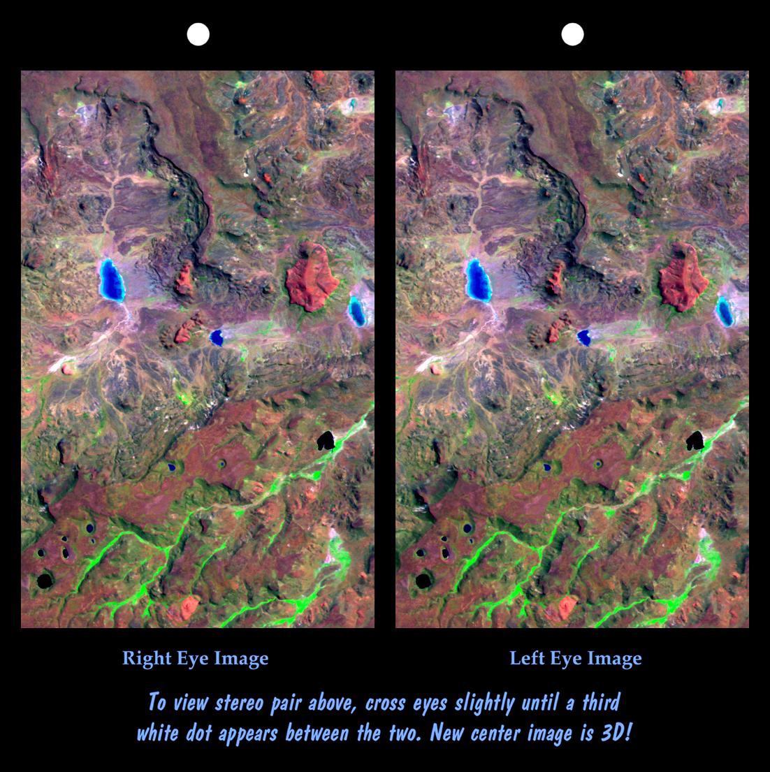
Storm clouds over Uluru.
ウルルの嵐の雲。
―――――――
Oct 1, 2007
オーストラリアの中心部には、地球上で見つかった最も奇妙な3つの岩層があります。 それらはゆっくりとした着実な侵食の過程で形成されたのでしょうか、それとも巨大な電流がそれらを引き寄せたのでしょうか?
もう一度、地球の異常な地理の調査で、いわば平地に隠れて、大陸の次元の領域に加えられた集中した電気力であったかもしれないものの例を見つけます。
オーストラリアの広大な空の中心には、その大きさに驚かされる3つの巨大なtors(岩山)があります。
それらは放電加工の痕跡を持っており、広範囲にわたる激しい混乱に関連しています。
マウントオーガスタスは世界最大のモノリスと見なされることもありますが、その場所では独立しており、ビッグ3とは密接に関連していません。
以前のサンダーボルツ「今日の写真」の記事では、オーストラリアと非常によく似たアフリカと米国の構造について説明しました。
私たちの結論は、それらは非常にエネルギーの高いプラズマ放電の結果である可能性があるため、オーストラリアの山塊も電気的起源である可能性があるというものでした。
この巨大な石達も互いに近接して配置されています。
それらの名前と場所は次のとおりです:
• Uluruウルル(エアーズロック) - 25° 11' 10" S X 130° 58' 32" E
〈https://ja.wikipedia.org/wiki/%E3%82%A6%E3%83%AB%E3%83%AB〉
• Mount Conner コナー山- 25° 29' 48" S X 131° 53' 56" E〈https://en.wikipedia.org/wiki/Mount_Conner〉
• Kata Tjutaカタジュタ(オルガス) - 25° 17' 46" S X 130° 45' 46" E〈https://ja.wikipedia.org/wiki/%E3%82%AB%E3%82%BF%E3%83%BB%E3%82%B8%E3%83%A5%E3%82%BF〉
歴史が記録される前から、オーストラリアのアボリジニの人々は、ビッグ3が位置する国のこの地域を神聖なものと見なしてきました。
土地は、神々と惑星が交差した場所として、彼らの創造物語に教え込まれています。
ドリームタイムと呼ばれる先史時代であり、生命と人類が誕生し、これらの形成が大きな役割を果たしました。
〈https://www.aboriginalart.com.au/culture/dreamtime2.html〉
多くの場所は部外者に禁じられており、より多くのアボリジニの土地を彼らの支配下に戻そうとする動きが高まっています。
3つのうち、ウルル(以前はエアーズロックと呼ばれていました)がおそらく最もよく知られています。
それは文学でロマンチックにされ、ドキュメンタリーで長年分析されてきました。
それでも、それは従来の説明に逆らい続けています。
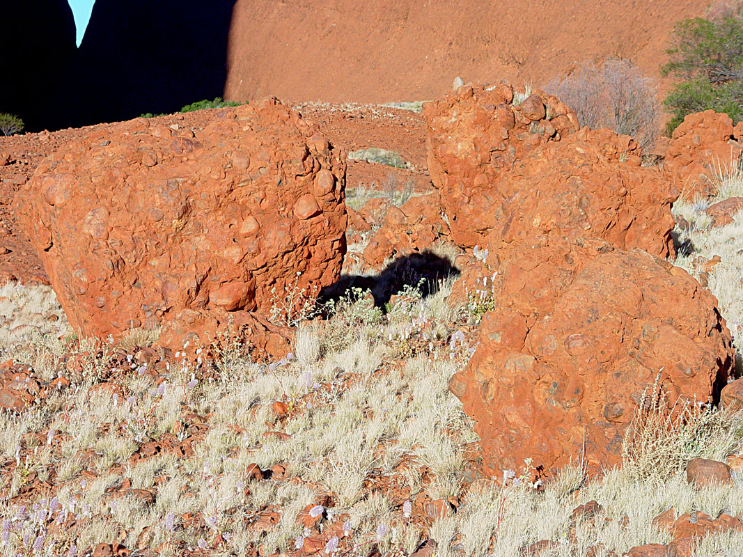
ウルルは、砂岩のマトリックスで固められた礫岩と砂利で構成されています。
それは、長さ3.6キロメートル、幅2キロメートルで、平野から345メートルの高さになります。
上部には、パタゴニアの「逆地形」でよく見られる「ショットガンブラスト」形状のクレーターチェーンと深い甌穴のクラスターとともに、平行に走る狭い尾根のある縞模様が表示されます。
〈https://photojournal.jpl.nasa.gov/jpeg/PIA02760.jpg〉
ウルルの全体的な形状とそれを取り巻く破砕された地形は、火星の軌道から送信された画像を示唆しています:
スカラップのエッジ、岩に切り込まれた多角形のパターン、砂丘、隆起したマウンド、小さなクレーター。〈http://cseligman.com/text/planets/candorlayers.jpg〉
3つの中の2番目の構造は、コナー山、またはアッティラです。〈https://en.wikipedia.org/wiki/Mount_Conner〉
ウルルの東88kmにあり、平らな卓上と馬蹄形で一目で区別できます。
他の見方では、山は拳または巨大な丸い砂岩のブロックの大きな山に似ています。
コナー山は海抜859メートルで、周囲の砂漠より300メートル高くなっています。
その2つのいとこと同様に、この山は同様の砂岩礫岩で構成されています。
〈http://www.astronomynotes.com/nature/images/olgawalk3.jpg〉
近くには、両側に何キロにもわたって弧を描いて伸びる2つの尾根があります。
それはまた、豊かなアボリジニの歴史と文化遺産を持っています。
ビッグ3の最後は、ウルルの西25kmにあるカタジュタ(オルガスとも呼ばれる)です。
〈https://ja.wikipedia.org/wiki/%E3%82%AB%E3%82%BF%E3%83%BB%E3%82%B8%E3%83%A5%E3%82%BF〉
カタジュタは3つの地質異常の中で最大のもので、36個の砂岩礫岩ドームで構成されています。
最高点は、オルガ山で、546メートルに上昇します。
ウルルのように、それはアナングの人々にとって神聖であり、今日でも主に彼らの精神的な儀式に特徴があります。
22平方キロメートルをカバーするカタジュタは、3つのモノリスの中で最大です。
それは、岩石と砂利の礫岩を囲む同じ砂岩マトリックスで構成されています。
これらのオブジェクトはサイズ、形状、構成が非常に似ているため、どのような力でオブジェクトを作成できるかを尋ねる必要があります。
標準的な説明は、それらは何十年にもわたって堆積した沖積堆積物から形成され、徐々に堆積岩を形成したというものです。
数億年後、風と雨が表土を一粒ずつ除去した後、地層は侵食によって露出されました。
過去の「今日の写真」で書いたように、これらのフォーメーションがそれほど昔ではない比較的短期間で作成されたという明確な可能性があります。
岩層を移動する電気アークの作用により、オーストラリアの奥地に存在するすべての物質がこれらの創造物に集められた可能性があります。
電気が流れると電磁力が発生し、磁場が最終的に小片を圧縮して固い塊にします。
岩、砂利、砂は砂岩礫岩の固化したブロックになる可能性があります。
スティーブン・スミス著
―――――――
Oct 1, 2007
In the center of Australia are three of the strangest rock formations found on Earth. Were they formed in a slow, steady process of erosion, or did immense electric currents pull them together?
オーストラリアの中心部には、地球上で見つかった最も奇妙な3つの岩層があります。 それらはゆっくりとした着実な侵食の過程で形成されたのでしょうか、それとも巨大な電流がそれらを引き寄せたのでしょうか?
Once again in our investigation of Earth's anomalous geography, hiding in plain site as it were, we find examples of what might have been concentrated electrical force applied over regions of continental dimension.
もう一度、地球の異常な地理の調査で、いわば平地に隠れて、大陸の次元の領域に加えられた集中した電気力であったかもしれないものの例を見つけます。
In Australia's vast empty center are three giant tors that are astonishing for their size.
オーストラリアの広大な空の中心には、その大きさに驚かされる3つの巨大なtors(岩山)があります。
They bear the marks of electric discharge machining and are associated with violent disruption over a wide area.
それらは放電加工の痕跡を持っており、広範囲にわたる激しい混乱に関連しています。
Although Mount Augustus is sometimes considered the largest monolith in the world, it stands alone in its locale and is not closely associated with the big three.
マウントオーガスタスは世界最大のモノリスと見なされることもありますが、その場所では独立しており、ビッグ3とは密接に関連していません。
Previous Thunderbolts Picture of the Day articles described structures in Africa and the United States that are very similar to those in Australia.
以前のサンダーボルツ「今日の写真」の記事では、オーストラリアと非常によく似たアフリカと米国の構造について説明しました。
Our conclusion was that they could be the result of highly energetic plasma discharges, so the Australian massifs may also be of electrical origin.
私たちの結論は、それらは非常にエネルギーの高いプラズマ放電の結果である可能性があるため、オーストラリアの山塊も電気的起源である可能性があるというものでした。
The giant stones are also located in close proximity to one another.
この巨大な石達も互いに近接して配置されています。
Their names and locations are:
それらの名前と場所は次のとおりです:
• Uluru - 25° 11' 10" S X 130° 58' 32" E
〈https://ja.wikipedia.org/wiki/%E3%82%A6%E3%83%AB%E3%83%AB〉
• Mount Conner - 25° 29' 48" S X 131° 53' 56" E〈https://en.wikipedia.org/wiki/Mount_Conner〉
• Kata Tjuta - 25° 17' 46" S X 130° 45' 46" E〈https://ja.wikipedia.org/wiki/%E3%82%AB%E3%82%BF%E3%83%BB%E3%82%B8%E3%83%A5%E3%82%BF〉
From before the time of recorded history, the Australian Aboriginal people have considered this part of the country where the big three are located to be sacred.
歴史が記録される前から、オーストラリアのアボリジニの人々は、ビッグ3が位置する国のこの地域を神聖なものと見なしてきました。
The land is inculcated in their creation stories as the place where gods and planets intersected.
土地は、神々と惑星が交差した場所として、彼らの創造物語に教え込まれています。
Called the Dreamtime, it is the prehistoric period when life and humanity came into being and these formations played a major role.
ドリームタイムと呼ばれる先史時代であり、生命と人類が誕生し、これらの形成が大きな役割を果たしました。
〈https://www.aboriginalart.com.au/culture/dreamtime2.html〉
Many places are forbidden to outsiders and there is a growing movement that seeks to bring more of the Aboriginal lands back under their control.
多くの場所は部外者に禁じられており、より多くのアボリジニの土地を彼らの支配下に戻そうとする動きが高まっています。
Of the three, Uluru (previously called Ayers Rock) is probably the most familiar.
3つのうち、ウルル(以前はエアーズロックと呼ばれていました)がおそらく最もよく知られています。
It has been romanticized in literature as well as analyzed in documentaries for many years.
それは文学でロマンチックにされ、ドキュメンタリーで長年分析されてきました。
Yet, it continues to defy conventional explanation.
それでも、それは従来の説明に逆らい続けています。
Uluru is composed of conglomerated stones and gravel, cemented by a matrix of sandstone.
ウルルは、砂岩のマトリックスで固められた礫岩と砂利で構成されています。
It is 3.6 kilometers long by 2 kilometers wide and rises to 345 meters above the plain.
それは、長さ3.6キロメートル、幅2キロメートルで、平野から345メートルの高さになります。
On top, it displays striations with narrow ridges running parallel, along with crater chains and clusters of deep potholes in the "shotgun blast" shape often found in the "inverted terrain" of Patagonia.
上部には、パタゴニアの「逆地形」でよく見られる「ショットガンブラスト」形状のクレーターチェーンと深い甌穴のクラスターとともに、平行に走る狭い尾根のある縞模様が表示されます。
〈https://photojournal.jpl.nasa.gov/jpeg/PIA02760.jpg〉
The overall shape of Uluru and the fractured topography surrounding it are suggestive of images sent from Mars orbit:
scalloped edges, polygonal patterns cut into the rock, dunes, raised mounds, and small craters.
ウルルの全体的な形状とそれを取り巻く破砕された地形は、火星の軌道から送信された画像を示唆しています:
スカラップのエッジ、岩に切り込まれた多角形のパターン、砂丘、隆起したマウンド、小さなクレーター。〈http://cseligman.com/text/planets/candorlayers.jpg〉
The second structure among the three is Mount Conner, or Attila.
3つの中の2番目の構造は、コナー山、またはアッティラです。〈https://en.wikipedia.org/wiki/Mount_Conner〉
It is eighty-eight kilometers east and slightly south of Uluru and can be distinguished in one view by its flat tabletop and horseshoe shape.
ウルルの東88kmにあり、平らな卓上と馬蹄形で一目で区別できます。
In other views, the mountain resembles a fist or a great pile of gigantic, rounded sandstone blocks.
他の見方では、山は拳または巨大な丸い砂岩のブロックの大きな山に似ています。
Mount Connor is 859 meters above sea level and is 300 meters higher than the surrounding desert.
コナー山は海抜859メートルで、周囲の砂漠より300メートル高くなっています。
Like its two cousins, the mountain is composed of similar sandstone conglomerate.
その2つのいとこと同様に、この山は同様の砂岩礫岩で構成されています。
〈http://www.astronomynotes.com/nature/images/olgawalk3.jpg〉
Nearby are two ridges that extend in sweeping arcs for many kilometers on either side.
近くには、両側に何キロにもわたって弧を描いて伸びる2つの尾根があります。
It also possesses a rich Aboriginal history and cultural heritage.
それはまた、豊かなアボリジニの歴史と文化遺産を持っています。
The last of the big three is Kata Tjuta (also called the Olgas), located 25 kilometers west of Uluru.
ビッグ3の最後は、ウルルの西25kmにあるカタジュタ(オルガスとも呼ばれます)です。
〈https://ja.wikipedia.org/wiki/%E3%82%AB%E3%82%BF%E3%83%BB%E3%82%B8%E3%83%A5%E3%82%BF〉
Kata Tjuta is the largest of the three geologic anomalies, comprising 36 sandstone conglomerate domes.
カタジュタは3つの地質異常の中で最大のもので、36個の砂岩礫岩ドームで構成されています。
The highest point is Mt. Olga, rising to 546 meters.
最高点は、オルガ山で、546メートルに上昇します。
Like Uluru, it is sacred to the Anangu people and features predominantly in their spiritual rites even to this day.
ウルルのように、それはアナングの人々にとって神聖であり、今日でも主に彼らの精神的な儀式に特徴があります。
Covering 22 square kilometers, Kata Tjuta is the largest of the three monoliths.
22平方キロメートルをカバーするカタジュタは、3つのモノリスの中で最大です。
It is composed of the same sandstone matrix surrounding a conglomerate of rocks and gravel.
それは、岩石と砂利の礫岩を囲む同じ砂岩マトリックスで構成されています。
Because these objects are so similar in size, shape and composition, it must be asked what forces could create them?
これらのオブジェクトはサイズ、形状、構成が非常に似ているため、どのような力でオブジェクトを作成できるかを尋ねる必要があります。
The standard explanation is that they were formed from alluvial deposits laid down over eons of time, gradually forming sedimentary rocks.
標準的な説明は、それらは何十年にもわたって堆積した沖積堆積物から形成され、徐々に堆積岩を形成したというものです。
After hundreds of millions of years, the formations were exposed through erosion after wind and rain removed the overburden grain by grain.
数億年後、風と雨が表土を一粒ずつ除去した後、地層は侵食によって露出されました。
As we have written in past Pictures of the Day, there is the distinct possibility that these formations were created in a relatively short period of time not so long ago.
過去の「今日の写真」で書いたように、これらのフォーメーションがそれほど昔ではない比較的短期間で作成されたという明確な可能性があります。
The action of electric arcs moving through rock strata could have gathered all the materials extant in the Australian outback into these creations.
岩層を移動する電気アークの作用により、オーストラリアの奥地に存在するすべての物質がこれらの創造物に集められた可能性があります。
Electromagnetic forces are generated when electricity flows and magnetic fields will ultimately compress the bits and pieces into a solid mass.
電気が流れると電磁力が発生し、磁場が最終的に小片を圧縮して固い塊にします。
Rocks, gravel and sand could become solidified blocks of sandstone conglomerate.
岩、砂利、砂は砂岩礫岩の固化したブロックになる可能性があります。
By Stephen Smith
スティーブン・スミス著