MARS and the GRAND CANYON
火星とグランドキャニオン
by Wal Thornhill | October 24, 2001 2:49 pm
“The ultimate objective of comparative planetology, it might be said, is something like a vast computer program into which we insert a few input parameters (perhaps the initial mass, composition and angular momentum of a protoplanet and the population of neighboring objects that strike it) and then derive the complete evolution of the planet.”
Carl Sagan, The Solar System, Scientific American, September 1975, p.29.
「比較惑星学の究極の目的は、いくつかの入力パラメータ(おそらく、原始惑星の初期質量、組成、角運動量、およびそれに衝突する近隣の天体の集団など)を挿入する巨大なコンピュータプログラムのようなものであると言えるかもしれません」 そして惑星の完全な進化を導き出します。」
カール・セーガン、「The Solar System」、Scientific American、1975 年 9 月、29 ページ。
First Law of Computing: Garbage in = garbage out.
コンピューティングの第一法則:
ゴミが入る = ゴミが出る。
Most people would think that experts agree on an explanation for the formation of such a grandiose site as the Grand Canyon.
ほとんどの人は、グランドキャニオンのような壮大な場所の形成に関する説明については専門家が同意していると考えるでしょう。
Surprisingly that isn’t so.
It is an enigma.
驚くべきことにそうではありません。
それは謎です。
The latest attempt to figure it out occurred as late as June last year at the Grand Canyon Symposium 2000.
それを解明しようとする最新の試みは、昨年6月遅くにグランドキャニオンシンポジウム2000で行われた。
The Colorado River is held generally responsible for carving the Canyon.
コロラド川は一般的に峡谷を彫る責任を担っていると考えられています。
However, even before the Glen Canyon dam stemmed its awesome desert floods, the river seems hopelessly inadequate to have formed such a geological spectacle.
しかし、グレンキャニオンのダムがその恐ろしい砂漠の洪水を食い止める前でさえ、この川はこのような地質学的光景を形成するには絶望的に不十分であるように思われます。
The Colorado River flows west from the Rockies and encounters a raised plateau known as the Kaibab Upwarp.
コロラド川はロッキー山脈から西に流れ、カイバブ アップワープとして知られる盛り上がった高原に出会います。
Instead of turning away from that barrier it continues through the plateau.
その障壁から回避するのではなく、プラトーを通過し続けます。
How could it do that?
どうしてそんなことができるのでしょうか?
The river is much younger than the Kaibab Upwarp so it could not have progressively cut the Canyon even if the land rose very slowly.
この川はカイバブ アップワープよりもはるかに若いため、たとえ土地が非常にゆっくりと隆起したとしても、川が峡谷を徐々に切り開くことはできませんでした。
In any case, most of the material that was removed from the Canyon seems to be missing, according to a report from the symposium, leaving little evidential support for the original theory that a simple progression of water erosion formed the Canyon we see today.
いずれにせよ、シンポジウムの報告書によると、峡谷から除去された物質のほとんどが失われているようで、単純な水浸食の進行によって今日私たちが見ている峡谷が形成されたという当初の理論に対する証拠的な裏付けはほとんど残っていない。
Since the 1930’s and 1940’s, geologists have searched for other explanations
— that the Canyon once drained to the south-east (reversing the route of the present-day Little Colorado, then joining the Rio Grande and into the Gulf of Mexico.
1930 年代と 1940 年代以来、地質学者は他の説明を探してきました
— 峡谷はかつて南東に流れ込んでいた(現在のリトルコロラドのルートを逆流して、リオグランデ川と合流してメキシコ湾に注いでいた)。
When problems arose with that explanation too, it was proposed that it once flowed NE along one of the present-day side tributaries such as Cataract Creek.
その説明にも問題が生じたとき、この川はかつてカタラクトクリークなどの現在の側支流の一つに沿って北東部を流れていたという提案が提案された。
70*

See: http://www.kaibab.org/geology/gc_geol.htm#how and The New York Times, June 6 2000, Making Sense of Grand Canyon’s Puzzles by Sandra Blakeslee]
およびニューヨーク・タイムズ紙、2000 年 6 月 6 日、サンドラ・ブレークスリーによるグランドキャニオンのパズルを理解する]
Now let us consider a 21st century solution to the question of how the Grand Canyon was formed, based not only on Earthly evidence, but also on data returned by space probes and produced by more than a century of experimental and theoretical work in plasma laboratories.
次に、グランドキャニオンがどのように形成されたかという問題に対する 21 世紀の解決策を、地球上の証拠だけでなく、宇宙探査機から返されたデータやプラズマ研究所での 1 世紀以上にわたる実験および理論研究によって生み出されたデータにも基づいて考えてみましょう。
The Grand Canyon has often been compared in form, if not size, to the gigantic canyons of Valles Marineris on Mars.
グランド キャニオンは、大きさはともかく、火星のマリネリス渓谷の巨大な峡谷とよく比較されます。
Because of these similarities it was initially thought that Valles Marineris was caused by massive water erosion at some earlier, supposedly wetter, epoch in Martian history.
これらの類似性のため、マリネリス峡谷は当初、火星史のもっと早い時期、より湿潤な時代に大規模な水の浸食によって生じたと考えられていた。
That idea has been abandoned because the evidence for water erosion and ponding in Valles Marineris is missing.
マリネリス渓谷の水の浸食と貯水の証拠が欠けているため、その考えは放棄されました。
The favored explanation now is that the surface of Mars has opened up with a giant tectonic rift, rather like the East African rift valley.
現在、火星の表面に東アフリカの地溝帯のような巨大な地溝帯が開いたというのが有力な説明である。
Rifting is usually accompanied by vulcanism caused by increased heat flow from the interior.
裂け目は通常、内部からの熱流の増加によって引き起こされる加硫現象を伴います。
Yet major volcanic features are lacking in Valles Marineris.
しかし、マリネリス渓谷には主要な火山の特徴が欠けています。
There are also many deep yet short tributary canyons, which require a different explanation.
深くて短い支流の峡谷もたくさんありますが、これらについては別の説明が必要です。
The favored one is undercutting by groundwater erosion.
有利なのは、地下水の浸食によるアンダーカットです。
Both on Earth and Mars the canyons seem to have been cut cleanly into a raised flat surface.
地球でも火星でも峡谷は、盛り上がった平らな面に、きれいに切り取られているように見える。
There is very little collateral damage to that surface.
その表面には付随的な損傷はほとんどありません。
Is it likely that two different causes could end up creating landforms on two planets that look so similar?
2 つの異なる原因により、非常によく似た 2 つの惑星の地形が形成される可能性はありますか?
71*

Both vast canyons confront us with enigmas. Is there a simple answer?
どちらの広大な峡谷も私たちに謎を突きつけます。 簡単な答えはあるのでしょうか?
At the heart of geology and planetary studies is a reasoning process called abduction.
地質学と惑星研究の中心には、アブダクションと呼ばれる推論プロセスがあります。
It is a form of logic whose major premise is certain and minor premise is probable.
これは、大前提が確実であり、小前提が蓋然的である論理形式です。
Then let us consider the question of flowing-liquid erosion.
次に、流動液体浸食の問題を考えてみましょう。
The major premise is “all sinuous channels are formed by a flowing liquid” and the minor premise is “Nirgal Vallis on Mars is a sinuous channel.”
大前提は「すべての曲がりくねった水路は流れる液体によって形成される」、小前提は「火星のニルガル渓谷は曲がりくねった水路である」です。
The deduction follows that “Nirgal Vallis was formed by a flowing liquid.”
「ニルガル峡谷は流れる液体によって形成された」という推論が導き出されます。
72*

However such reasoning can be hopelessly misleading if the major premise is not certain.
しかしながら、大前提が確かでない場合、そのような推論は絶望的に誤解を招く可能性があります。
Mars is a desert planet with no possibility of flowing liquids today nor, it seems, for a long time past.
火星は砂漠の惑星であり、現在も液体が流れる可能性はありませんし、過去にも長い間存在していないようです。
But the huge channels look as if they were carved yesterday.
しかし、巨大な水路はまるで昨日彫られたかのように見えます。
That should be sufficient to doubt the major premise.
それは、大前提を疑うには十分なはずです。
However lazy logic forces us simply to conclude that there must have been large quantities of liquid water on Mars in the past.
しかし、怠惰な論理では、火星には過去に大量の液体の水が存在したに違いないと単純に結論付けることになります。
That is the present consensus.
それが現在のコンセンサスです。
So typically the missing water has been conveniently consigned out of sight, beneath the Martian surface.
したがって、通常、失われた水は火星の地表の下で目に見えないところに都合よく隠蔽されている事になっています。
The same thing was said of the channels on the Moon before the Apollo missions proved otherwise.
アポロ計画で、そうではないことが証明される前は、月のチャンネルについても同じことが言われていました。
Once again this incurious approach has led to huge expenditure on new spacecraft to detect sub-surface ice on Mars.
この奇妙なアプローチにより、火星の地下の氷を検出するための新しい探査機への巨額の支出が再び発生しました。
What if the major premise is completely wrong?
大前提が完全に間違っていたらどうなるでしょうか?
What if none of the sinuous channels (usually called ‘rilles’) on Mars, Venus and our Moon, were originally formed by flowing liquids?
火星、金星、月にある曲がりくねった水路(通常は「リル」と呼ばれます)が、もともと流れる液体によって形成されていなかったらどうなるでしょうか?
This is a key question to be answered before we can address the more complex canyons on Mars and here on Earth.
これは、火星や地球上のより複雑な峡谷に取り組む前に、答えるべき重要な質問です。
Rilles have the same form on all of these bodies, yet no one today seriously suggests that we look for water on the furnace-hot surface of Venus or on the airless Moon.
リルはこれらの天体すべてに同じ形をしていますが、今日、炉で熱い金星の表面や、空気のない月に、水を探すことを真剣に提案する人は誰もいません。
Instead, hot fluid lava has been called upon as the flowing liquid on these bodies.
代わりに、これらの天体上を流れる液体として、高温の流体溶岩が求められています。
The problem is that the lava had to remain liquid over hundreds, and in some cases thousands, of miles.
問題は、溶岩が数百マイル、場合によっては数千マイルにわたって液体のままでなければならなかったということです。
So a roof of rock was added, to form lava tubes.
そこで、溶岩洞を形成するために、岩の屋根が追加されました。
But some of those roofs needed to be miles wide!
しかし、屋根の中には何マイルもの幅が必要なものもありました!
Some rilles on the Moon and Venus are wider than the longest lava tubes on Earth.
月と金星のいくつかのリルは、地球上で最も長い溶岩洞よりも幅が広いです。
And the rock roofs had to collapse later to expose the channels.
そして、水路を露出させるために、後で岩の屋根が崩れなければなりませんでした。
There is no rubble from collapsed roofs in any of the rilles.
どのリルにも倒壊した屋根の瓦礫はありません。
The rilles are cleanly chiselled into the surface.
表面にはリルがきれいに彫り込まれています。
The lava is supposed to have flowed billions of years ago on the Moon, and only millions of years ago on Venus.
溶岩は月では数十億年前、金星ではわずか数百万年前に流れたと考えられています。
A good example of a lunar rille, photographed in great detail by the Apollo astronauts, is Schröter’s Valley.
アポロ宇宙飛行士によって詳細に撮影された月リールの好例は、シュレーダーの谷です。
The channel looks brand new.
チャンネルは真新しいようです。
Once again, the liquid that is supposed to have cut the channel is missing
– there is no lava outflow.
またしても、溝を切ったはずの液体がなくなった
– 溶岩の流出はありません。
And lava cannot seep into the ground and be hidden as water can.
そして、溶岩は水のように地面に浸透して隠れることはできません。
Something is wrong with this picture.
この写真は何かが間違っています。
The major premise must be wrong.
この大前提が間違っているはずだ。
73*

There are many more mysterious features of these channels.
これらのチャネルには、さらに多くの謎に満ちた特徴があります。
Their wider “outflow” end is higher than the narrow “source” end, as if whatever formed them was not responding to gravity.
それらの広い「流出」端は、狭い「ソース(供給)」端よりも高く、あたかもそれらを形成するものは重力に反応していないかのようです。
In flagrant breach of that law, some run both uphill and down with no sign of the damage that might be expected if the topographical changes were due to later vertical movement of the terrain.
この法律のあからさまな違反では、地形の変化がその後の地形の垂直移動によるものである場合に予想される被害の兆候を示さずに、上り坂も下り坂も走るものもいます。
Others cut through mountain ridges as if they were not an obstacle.
まるで障害物ではないかのように山の尾根を突っ切るものもいる。
Unlike rivers, rilles often run in parallel.
川とは異なり、リルは並行して流れることがよくあります。
Some have circular craters along their length, others seem to be formed from a continuous series of pits.
全長に沿って円形のクレーターがあるものもあれば、連続した一連の穴から形成されているように見えるものもあります。
Most terminate on a crater.
ほとんどは、1つのクレーターで終わります。
Because of the many craters found in and around them, dating the rilles by crater counting makes them appear older than the surface they cut into.
リルの中やその周囲には多くのクレーターが見られるため、クレーターを数えて年代を特定すると、その表面よりも古いもののように見えます。
The channels are often much more sinuous for their width or the slope of the surface, than would be expected if they had been carved by a liquid.
チャネルは、その幅や表面の傾斜の点で、液体によって削られた場合に予想されるよりもはるかに曲がりくねっていることがよくあります。
Some have a smaller, more sinuous channel in the floor of the larger channel.
大きな水路の床に、より小さくて曲がりくねった水路を備えたものもあります。
Some have flat floors and steep walls.
一部には平らな床と急な壁があります。
Others have a deep V-shaped cross-section.
その他には、断面が深いV字型のものもあります。
Tributaries, if any, are often short, end in a circular alcove, and join the main channel at near right angles.
支流があるとしても、多くの場合短く、円形のくぼみで終わり、ほぼ直角で本流と合流します。
To explain these (on worlds with water), recourse is usually made to underground water flows that remove soil and cause collapse and progressive headward erosion of the channel.
これら(水のある世界について)を説明するには、通常、土壌を除去し、水路の崩壊と進行性の前向性侵食を引き起こす地下水の流れに頼ることになります。
Many channel floors show transverse markings or small ridges.
多くの水路床には横方向の模様や小さな隆起が見られます。
On Mars they have been described as sand dunes.
火星では、それらは砂丘として説明されています。
Many channels have material heaped up on each side to form levees.
多くの水路では、堤防を形成するために両側に資材が積み上げられています。
There are neither catchment areas nor systems of feeder streams sufficient to carve the often-gigantic main channels or tributary streams.
多くの場合、巨大な本水路や支流を切り開くのに十分な集水域も支流システムもありません。
The source and sink of the water remains invisible.
水源とシンクは見えないままです。
And the question remains:
where did the eroded soil go?
そして疑問が残ります:
侵食された土はどこへ行ったのでしょうか?
“The real actors on the stage of the universe are very few, if their adventures are many.
「宇宙の舞台に立つ本物の俳優は、冒険がたくさんあるとしても、ごく少数です。
The most ‘ancient treasure’
-in Aristotle’s words-
that was left to us by our predecessors of the High and Far-off Times was the idea that the gods are really stars, and that there are no others.
最も「古代の宝物」
~アリストテレスの言葉~
それは私たちの前任者の高さと遠くの時間によって私たちに残されました、それは、神々は実際には星々であり、他には存在しないという考えでした。
The forces reside in the starry heavens, and all the stories, characters and adventures narrated by mythology concentrate on the active powers among the stars, who are planets.”
力は星空に存在しており、神話によって語られるすべての物語、登場人物、冒険は、惑星である星々の間で活動する力に集中しています。」
Giorgio Di Santillana and Hertha von Dechend in Hamlet’s Mill.
ハムレット工場のジョルジョ・ディ・サンティジャーナとヘルタ・フォン・デヘント。
“The thundergod is regarded as the most powerful of all the gods of heaven and earth, since the effects of his anger are so terrible and so evident.” Christopher Blinkenberg in The Thunderweapon in Religion and Folklore.
「雷神は、その怒りの影響が非常に恐ろしく、明らかであるため、天と地のすべての神の中で最も強力であると考えられています。」 クリストファー・ブリンケンバーグの『宗教と民俗におけるサンダーウェポン』。
See http://www.users.qwest.net/~mcochrane/Thundergods/thundergods.html[1]
The answer has been available for 30 years!
答えは30年前から用意されていました!
It was provided by an engineer, the late Ralph Juergens, of Flagstaff, Arizona.
これは、アリゾナ州フラッグスタッフのエンジニア、故ラルフ・ジョーガンス(=ユルゲンス)によって提供されました。
In a brilliant series of papers that would not be published in a mainstream scientific journal, he showed that flowing liquids are not adequate or even necessary to explain river-like channels on planets and their moons.
主流の科学雑誌には掲載されないであろう一連の素晴らしい論文の中で、彼は、惑星や衛星の川のような水路を説明するのに、流れる液体は適切ではない、あるいは必要さえないことを示しました。
He showed how the strange features of those channels could be simply scaled down and matched against the kind of damage caused by powerful lightning strikes on Earth.
彼は、これらのチャンネルの奇妙な特徴を、地球上の強力な落雷による被害に対して、簡単に縮小して一致させる方法を示しました。
So even if Mars had surface moisture in the past its vast channels were not carved by rushing water.
したがって、たとえ過去に火星の表面に湿気があったとしても、その広大な水路は激しい水によって削られることはなかった。
74*

〈Example of a powerful lightning strike at Baker, Florida in 1949. It furrowed the infield for 40 feet during a baseball game, killing 3 players and injuring 50 others. The more sinuous path taken by the lightning can be seen as a smaller trench in the bottom of the furrow. National Geographic, June 1950, p.827〉
〈1949 年にフロリダ州ベイカーで発生した強力な落雷の例。野球の試合中に落雷が内野を 40 フィートも荒らし、3 人の選手が死亡、50 人が負傷した。 雷がたどった、より曲がりくねった経路は、溝の底にある小さな溝として見ることができます。 ナショナル ジオグラフィック、1950 年 6 月、p.827〉
When we look at the pattern of a lightning scar on Earth we see the features of sinuous rilles in miniature.
地球上の稲妻の傷跡のパターンを見ると、曲がりくねったリルの特徴がミニチュアで見られます。
Electrical phenomena exhibit the same forms from the scale of centimeters to the scale of thousands of kilometers.
電気的現象はセンチメートルスケールから数千キロメートルスケールまで同じ形を示します。
In fact, it has been shown in high-energy electrical experiments that the same patterns of behavior can be scaled up yet another 100 million times.
実際、高エネルギー電気実験では、同じ動作パターンをさらに 1 億倍に拡大できることが示されています。
Because of this, the forms of scars on insulators and semiconductors and/or the surface erosion of spark-machined objects, seen under a microscope, can be used as analogs of electrical scarring of planetary surfaces.
このため、顕微鏡で観察した絶縁体や半導体の傷跡、および/または火花加工された物体の表面侵食の形状は、惑星表面の電気傷跡の類似物として使用できます。
Plasma cosmology can do inexpensive controlled experiments on Earth to answer puzzles that have plagued planetologists for decades.
プラズマ宇宙論は、数十年にわたって惑星学者を悩ませてきた謎に答えるために、地球上で安価に管理された実験を行うことができます。
75*

Without a shadow of a doubt, Valles Marineris is an electrical arc scar.
疑いの余地なく、マリネリス渓谷は電気アークの傷跡です。
It bears the hallmarks, writ large on a planet’s face.
それは惑星の表面に大きく書かれた特徴を持っています。
Juergens identified it as such 30 years ago from the early Viking Orbiter spacecraft images.
ジョーガンス(=ヨーガンス、=ユルゲンス)氏は、初期のバイキング・オービター宇宙船の画像から30年前にそれがそのようなものであると特定しました。
“… to me this entire region resembles nothing so much as an area sapped by a powerful electric arc advancing unsteadily across the surface, occasionally splitting in two, and now and then-weakening, so that its traces narrow and even degrade into lines of disconnected craters.
「…私にとって、この地域全体は、地表を不安定に進み、時には真っ二つに裂ける強力な電気アークによって消耗された地域としか似ていません、そして時々弱まり、その痕跡は狭くなり、途切れたクレーターの線にさえ悪化します。
…I can only wonder:
Is it possible that Mars was bled of several million cubic kilometers of soil and rock in a single encounter with another planetary body?
…私にはただ不思議に思うことしかできません。
火星が別の天体と一度遭遇しただけで、数百万立方キロメートルの土や岩石が流出した可能性はあるのでしょうか?
Might the Canyonlands of Mars have been created in an event perhaps hinted at by Homer when he wrote: “Athena [Venus) drove the spear straight into his [Ares’ (Mars’)] belly where the kilt was girded:
the point ran in and tore the flesh… [and] Ares roared like a trumpet…”
火星の峡谷は、おそらくホーマーが次のように書いたときに示唆された出来事で作成されたのかもしれません:
「アテナ[ヴィーナス]は、キルトを締めていた彼の[アレス(マルス)]の腹にまっすぐ槍を突き刺した。
先端が突き刺さって肉を引き裂いた…[そして]アレスはトランペットのように咆哮を上げた…」
Juergens’ explanation requires a dynamic recent history of the solar system, entirely different from the one we have been taught to believe.
ジョーガンスの説明には、私たちが信じるよう教えられてきたものとはまったく異なる、太陽系のダイナミックな最近の歴史が必要です。
It highlights an electrical dimension to astrophysics which is nowhere to be found in their textbooks.
それは、教科書のどこにも載っていない、天体物理学の電気的側面を強調しています。
So it is little wonder that geologists are clueless when confronted with electrical erosion.
したがって、地質学者が電気浸食に直面したときに無知であるのも不思議ではありません。
When planets come close, gargantuan interplanetary lightning results.
惑星が接近すると、巨大な惑星間雷が発生します。
It is perfectly capable of stripping rock and gases from a planet against the puny force of gravity.
それは重力の微弱な力に抗して惑星から岩石やガスを完全に剥ぎ取ることができます。
It does so leaving characteristic scars.
そうすることで特徴的な傷跡が残ります。
It can explain why some two million cubic kilometers of material is missing from Valles Marineris along with 90% of the atmosphere Mars was expected to have.
これは、火星にあると予想されていた大気の90%とともに、約200万立方キロメートルの物質がマリネリス渓谷から失われた理由を説明できる。
A subsurface arc through an electrically coherent stratum can explain the peculiar morphology of Valles Marineris.
電気的に一貫した地層を通る地下アークは、マリネリス渓谷の独特の形態を説明できる可能性があります。
The parallelism of the canyons is due to the long-range magnetic attraction of current filaments and their short-range strong electrostatic repulsion.
峡谷の平行性は、電流フィラメントの長距離の磁気吸引力と、短距離の強力な静電反発力によるものです。
Particularly significant are the small parallel rilles composed essentially of chains of craters.
特に重要なのは、本質的にクレーターの連鎖で構成される小さな平行なリルです。
A traveling underground explosion follows the lightning streamer and cleanly forms the V-shaped tributary canyons.
進行中の地下爆発は稲妻の流れに続き、V 字型の支流の峡谷をきれいに形成します。
There is no collapse debris associated with undercutting water flow.
水流のアンダーカットに伴う崩落破片はありません。
Similarly, the “V” cross-section is usual for craters formed by underground nuclear explosions.
同様に、地下の核爆発によって形成されたクレーターでは、「V」字型の断面が一般的です。
The circular ends of the tributaries, where the explosion began, are precisely of that shape.
爆発が始まった支流の円形の端は、まさにその形状です。
In comparison, headward erosion by ground water sapping gives a U-shaped cross-section and does not necessarily end in a circular alcove.
比較すると、地下水の浸出による正面方向の侵食は U 字型の断面を与え、必ずしも円形のアルコーブ(床の間)で終わるとは限りません。
Note that some of the tributary canyons on the south rim of Valles Marineris cut across one another at near right angles.
マリネリス渓谷の南縁にある支流の峡谷の一部が互いにほぼ直角に交差していることに注意してください。
This might be due to repeated discharges from the same area chasing the main stroke as it travelled along Ius Chasma.
これは、イウス・キャズマに沿って進行する主要なストロークを追いかけて、同じ領域から繰り返し放電されたことが原因である可能性があります。
No form of water erosion can produce crosscutting channels like that.
いかなる形態の水浸食もそのような横断的な水路を作り出すことはできません。
The fluted appearance of the main canyon walls is probably due to the same travelling explosive action.
峡谷の主壁の溝状の外観は、おそらく同じ移動爆発作用によるものと考えられます。
76*
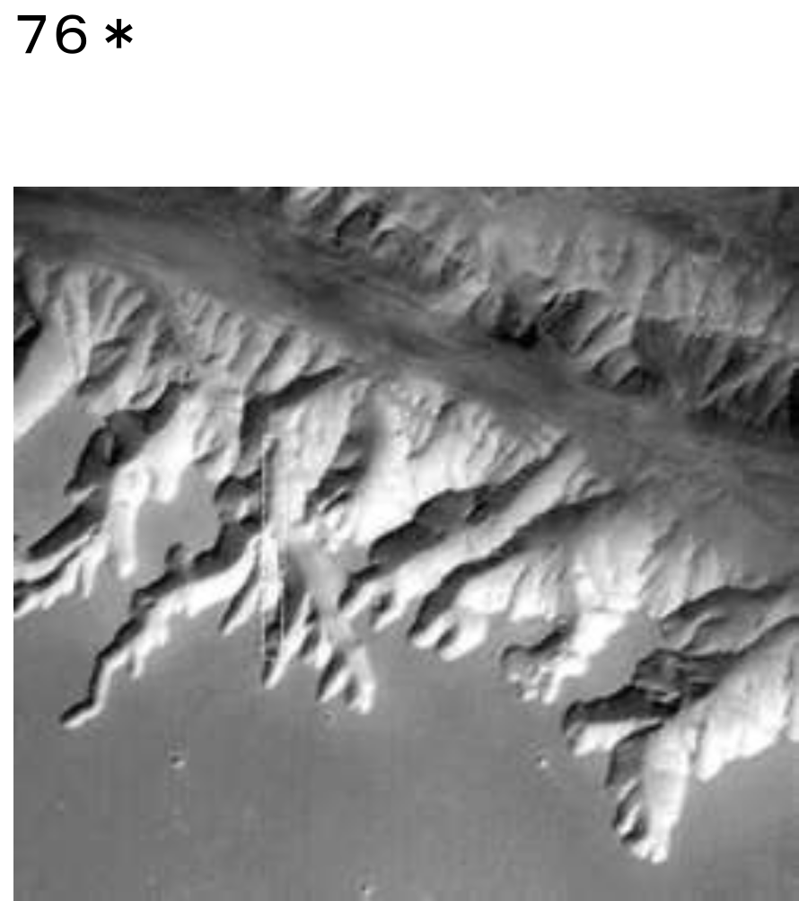
〈The system of V-shaped tributary canyons along the south rim of Ius Chasma on Mars (7°S, 82°W).
〉〈火星のイウス・カスマの南縁(南緯7度、西経82度)に沿ったV字型の支流峡谷系。
〉
The walls of Valles Marineris shows evidence of widespread sedimentary layering on Mars.
マリネリス渓谷の壁には、火星に広範囲に堆積物が層を成している証拠が示されています。
But such enormous quantities of sediment must have eroded from somewhere and the fact that any ancient highlands are preserved on Mars is difficult to reconcile with such a source.
しかし、これほど大量の堆積物はどこかから侵食されたに違いない、そして、古代の高地が火星に保存されているという事実を、そのような情報源と一致させるのは困難です。
A second major difficulty is that Valles Marineris is near the top of a bulge 10 km above datum.
2 番目の大きな問題は、マリネリス峡谷が基準線より 10 km 高い隆起の頂上付近にあることです。
How are sediments deposited at that altitude?
その高度では堆積物はどのようにして堆積するのでしょうか?
It would require the region first being a deep basin to collect a thick stack of sediments (assuming there was copious fast-running surface water), then uplifted an incredible 20 km by a mantle plume and voluminous lava intrusions with little surface volcanism.
そのためには、まずその地域が堆積物の分厚い堆積物を集める深い盆地であり(大量の高速流の地表水があったと仮定して)、その後マントルプルームと大量の溶岩の貫入によって、地表火山活動がほとんどなく、信じられないほど20kmも隆起する必要がある。
How many major premises in geology are wrong?
地質学の、間違っている主要な前提が、いくつあるのでしょうか?
The electrical model provides a far simpler solution never considered before in sedimentation.
電気的モデルは、沈降においてこれまで考慮されたことのない、はるかに単純なソリューションを提供します。
The material removed electrically from one body in a cosmic discharge is transferred in large part to the other body.
宇宙放電によって一方の天体から電気的に除去された物質の大部分は、もう一方の天体に移動します。
That creates widespread surface layering.
これにより、広範囲にわたる表面層が形成されます。
The airless Moon shows evidence too of extensive layering and it is covered in electrical scars.
空気のない月も広範囲にわたる層の証拠を示しており、電気的な傷跡で覆われています。
The arguments for the electrical sculpting of Valles Marineris apply equally to the Grand Canyon.
マリネリス渓谷の電気彫刻に関する議論は、グランド・キャニオンにも同様に当てはまります。
These major features on two very different planets look so similar for the simple reason that the same forces created them.
2 つのまったく異なる惑星にあるこれらの主要な地形が非常に似ているのは、同じ力がそれらを作成したという単純な理由からです。
Water was not involved in the process.
このプロセスには水は関与していません。
Let us note the similarities.
類似点に注目してみましょう。
The Grand Canyon is on a high plateau.
グランドキャニオンは高原にあります。
The tributaries are deeply incised, short, and tend to end in rounded alcoves.
支流は深く切り込まれており、短く、丸いアルコーブ(床の間)で終わる傾向があります。
The tributary canyons of Ius Chasma are strikingly similar to those of the Grand Canyon.
イウス・チャズマの支流の峡谷は、グランド キャニオンの峡谷に驚くほど似ています。
The material excavated from the Grand Canyon seems to be missing.
グランドキャニオンから発掘された資料は行方不明のようです。
On a watery Earth, the Colorado river simply took advantage of the sinuous channel carved by the subsurface cosmic lightning.
水の多い地球では、コロラド川は、地下の宇宙雷によって刻まれた曲がりくねった水路を利用しただけでした。
The edges of the Grand Canyon are sharp and do not show much erosion into the mile deep valleys.
グランドキャニオンの端は鋭く、そして、1マイル級の深い谷への浸食はあまり見られません。
That argues for very recent formation.
それは最近の形成を主張しています。
Geologists cannot decipher the history of the Grand Canyon because their training never envisaged electrical erosion as a result of interplanetary thunderbolts.
地質学者はグランドキャニオンの歴史を解読することができません、なぜなら、彼らの訓練では惑星間の落雷の結果としての電気浸食が想定されていなかったためです。
Nor did it teach that thick strata and anomalous deposits can be dumped from space in hours.
その厚さの層および異常な堆積物は、宇宙空間から数時間で積み重ねることができます。
Interplanetary electrical forces can raise mountains, twist and overturn strata, dump oceans on to land, preserve shattered flora and fauna in the rocks
– all in a geological instant.
惑星間の電気力は、山を隆起させ、地層をねじり、ひっくり返し、海を陸地に放り出し、粉々になった動植物を岩の中に保存することができます
- 全てを地質学的瞬間に。
But since Lyell, geologists have managed to lull us all into insensibility with vast time spans and piecemeal explanations for each morphological feature of the landscape.
しかし、Lyell以来、地質学者は、私たち全員を、風景のそれぞれの形態的特徴について、膨大な時間間隔と断片的な説明を伴う無感覚への移行に陥れることに成功しました。
The question that should be asked is whether the slow causes they invoke are sufficient to the task they are asked to perform.
問われるべき問題は、彼らが呼び出す遅い原因が、彼らに実行を求められたタスクに十分であるかどうかです。
Fossils do not form under normal circumstances.
化石は通常の状況では形成されません。
The sharp outlines of mountains and the tortured strata within them look like still frames from a dramatic action movie.
山の鋭い輪郭とその中の苦悶の地層は、劇的なアクション映画の静止画のように見えます。
And when it comes to assigning ages, cosmic thunderbolts cause radioactivity, change radioactive decay rates, and add and subtract radioactive elements.
そして、年齢の割り当てに関して言えば、宇宙の落雷は放射能を引き起こし、放射性崩壊率を変化させ、放射性元素を加算および減算します。
So the assumptions underpinning the rickety edifice of geological dating will need re-examination without prejudice.
したがって、地質年代測定の不安定な構造を支えている仮定は、偏見なく再検討する必要があるでしょう。
Geologists are between a rock and a hard place because the main claim of geology to being a “hard” science has come from its bold claims to chart the history of the Earth.
地質学者は岩と硬い場所の間にいます、なぜなら、地質学が「難しい」科学であるという主な主張は、地球の歴史を図表化するという大胆な主張から来ているからです。
But it is clear that the chart they have been handed by cosmogonists and the clock bequeathed by the physicists are equally worthless.
しかし、コスモゴニスト(宇宙起源進化論学者から渡された宇宙図や物理学者から遺された時計も同様に価値がないことは明らかです。
77*

It is interesting to find that NASA and the SETI Institute have set up a base camp on Devon Island, Nunavut Territory, in the Canadian high arctic, for the scientific study of the Haughton impact crater and its surroundings.
NASAとSETI研究所が、ホートン衝突クレーターとその周辺の科学的研究のために、カナダ高地北極のヌナブト準州デボン島にベースキャンプを設置したことは興味深い。
The joint study is known as the Haughton Mars project because the unexplored island is considered a Mars analog.
この共同研究は、この未踏の島が火星の類似物と考えられているため、ホートン火星プロジェクトとして知られています。
Mars analogs are sites on the Earth where geologic features approximate those encountered on Mars.
火星の類似点は、地質学的特徴が火星で遭遇するものに近似している地球上の場所です。
Devon Island has channels described as glacial meltwater networks.
デボン島には、氷河融解水のネットワークと呼ばれる水路があります。
Several types of valleys resemble those seen on Mars.
いくつかの種類の谷は火星で見られる谷に似ています。
The resemblance appears to be more than superficial, as the similarities are often specific and unique.
類似点は多くの場合具体的でユニークであるため、類似点は表面的なものではないようです。
They have been compared to the tributary canyons of Valles Marineris and are claimed as perhaps the clearest evidence for episodes of sustained fluid erosion on Mars by water.
それらはマリネリス渓谷の支流の峡谷と比較されており、水による火星の持続的な流体浸食のエピソードのおそらく最も明確な証拠であると主張されています。
However they present many unusual characteristics that cannot be explained by water erosion:
しかし、それらは水の浸食では説明できない多くの異常な特徴を示します:
1. the valleys are spaced apart with large undissected areas between valleys,
谷間には大きな未解剖領域があり、谷間が離れています。
2. the valleys display open, branching patterns with large undissected areas between branches,
谷は開いた分岐パターンを示し、枝の間に大きな未解剖領域があります。
3. branches often have ill-defined sources but mature in width and depth over short distances relative to the size of the network,
枝には供給源が明確に定義されていないことがよくありますが、ネットワークのサイズに比べて短い距離で幅と深さが成熟します。
4. branches maintain relatively constant width and depth over long distances,
枝は長距離にわたって比較的一定の幅と深さを維持します。
5. branches split and rejoin to form steep-walled islands,
枝が分かれたり、再び集まったりして、険しい壁に囲まれた島を形成します。
6. branches have V-shaped cross-sections which transition to larger U-shaped troughs with steep walls and flat floors,
枝は V 字型の断面を持ち、急な壁と平らな床を備えた大きな U 字型の谷に移行します。
7. channels on valley floors are absent or poorly expressed.
谷底のチャネルが存在しないか、発現が不十分です。
Their scale also varies over an order of magnitude.
それらの規模もまた、桁違いに異なります。
78*

< Aerial photograph of a 1 km-wide, deeply-incised, winding, V-shaped glacial trough valley on Devon Island with its tributaries.
Note that the surrounding plateau is otherwise little dissected and that there are no major streams feeding onto this canyon. (Photo: NASA HMP) V-shaped Devon Island valley. >
<デボン島にある幅 1 km の、深く切り込まれた曲がりくねった V 字型の氷河谷とその支流の航空写真。
それ以外の場合、周囲の台地はほとんど切り開かれておらず、この峡谷に流れ込む主要な川がないことに注意してください。 (写真: NASA HMP) デボン島の V 字型の渓谷。 >
Here we have a different explanation from geologists for essentially the same morphological feature.
ここでは、本質的に同じ形態学的特徴について、地質学者とは異なる説明が得られます。
The Devon valley networks are merely interpreted to be glacial meltwater channel networks formerly lying under an ice sheet. Some valleys do have a little ice in them today.
デボン渓谷のネットワークは、かつては氷床の下にあった氷河融解水路ネットワークであると単に解釈されています。 現在は、一部の谷に少し氷が張っています。
However, the arguments for their formation by the action of ice make little sense.
しかしながら、氷の作用によってそれらが形成されるという議論はほとんど意味がありません。
It suggests that glacial melting on a cold desert planet formed some Martian valley networks, which is hardly helpful.
これは、寒い砂漠の惑星での氷河の融解が火星の谷のネットワークを形成したことを示唆していますが、ほとんど役に立ちません。
The strong similarities between the Devon valley networks and the tributaries of Valles Marineris, like that of the Grand Canyon to Valles Marineris, is simply because they were formed by the same process
– a cosmic electric discharge.
デボン渓谷のネットワークとマリネリス渓谷の支流との間の強い類似点は、グランドキャニオンからマリネリス渓谷へのネットワークと同様に、それは単純に同じプロセスで形成されたからです
– 宇宙の電気放電。
All of the unusual features listed above are expected in cathode erosion.
上記に列挙した異常な特徴はすべて、陰極侵食(腐蝕)で発生すると予想されます。
Even the nearby Haughton crater is to be expected, for the same reason that rilles on other planets and moons are associated with craters and often have more craters than the surrounding landscape.
他の惑星や衛星のリルにはクレーターがあり、周囲の風景よりも多くのクレーターがあるのと同じ理由で、近くのホートン クレーターでさえも予想されます。
The Haughton crater is simply the scar of a cosmic thunderbolt, like practically every other circular crater in the solar system.
ホートン クレーターは、太陽系の他の円形クレーターと同様に、単なる宇宙の落雷の傷跡です。
So NASA is correct in their choice of analog, but wrong in their attribution of causes.
したがって、NASA はアナログの選択においては正しいですが、原因の帰属においては間違っています。
In light of more than a century’s research in the field of plasma cosmology and the 20th century discoveries of the space age, we can confidently propose the celestial thunderbolt as a common cause of the formation of canyons and rilles on rocky planets and moons.
プラズマ宇宙論の分野における 1 世紀以上の研究と、宇宙時代の 20 世紀の発見を考慮すると、岩石惑星や月における峡谷やリルの形成の共通の原因として天の落雷があると自信を持って提案できます。
See: http://www.arctic-mars.org/docs/03c.LPSC.pdf[2]
There is a geological perspective on planetary scars available
惑星の傷跡についての地質学的視点が利用可能です
at: http://disc.sci.gsfc.nasa.gov/geomorphology/GEO_10
where the difficulties facing geologists are often expressed.
ここでは、地質学者が直面する困難がよく表現されています。
With the perspective offered here you may begin to form your own opinion.
ここで提供される視点をもとに、あなた自身の意見を形成し始めるかもしれません。
Endnotes:
1. http://www.users.qwest.net/~mcochrane/Thundergods/thundergods.html: http://www.users.qwest.net/~mcochrane/Thundergods/thundergods.html
2. http://www.arctic-mars.org/docs/03c.LPSC.pdf: http://www.arctic-mars.org/docs/03c.LPSC.pdf
Source URL: https://www.holoscience.com/wp/mars-and-the-grand-canyon/