ザ・サンダーボルツ勝手連 [Cradle Mountain, Tasmania タスマニア州クレイドル・マウンテン]
[Cradle Mountain, Tasmania タスマニア州クレイドル・マウンテン]
Stephen Smith April 21, 2013 - 21:53Picture of the Day

クレイドル山
――――――――
Apr 22, 2013
タスマニアのドレライト(粗粒玄武岩)構造は電気層である可能性がありますか?
オーストラリア南部のタスマニア島は、地球上で最も挑発的なスポットの1つです。
〈http://www.about-australia.com/facts/tasmania/history/〉
植物の驚くべき多様性と他では見られないユニークな動物は、あらゆる分野の科学者達に、研究にほぼ理想的な条件を提供してきました。
このエコロジーは、初期の船に積み込まれたネズミと、その後ネズミを殺すために輸入されたネコは、在来の動物に劇的な(そして時には壊滅的な)影響を与えましたが、移植された動物からの侵入はほとんどありませんでした。
クレイドル山は、すべての大陸(および海の下)で見られる神秘的な石のモノリスの別の例として適格である可能性があります。
他のオーストラリアのフォーメーションとは異なり、クレイドル山は、完全に砂岩と、珪岩、砂岩、貝殻の緩い集合体、および周辺地域で見つかったあらゆる鉱物のコレクションで構成されており、ドレライトの固い塊、または凝結した玄武岩溶岩です。
〈http://thunderbolts.info/tpod/2007/arch07/071017bigthree.htm〉
タスマニアは、従来のモデルによると、「数百万年前」に発生した激しい地質学的活動を示しています。
山岳の隆起、深く急な側面の峡谷、石の「針」は、周囲の海から浮かび上がるものや、内部に見られる多くの火口湖は、プレートの動きによる火山噴火の跡と言われています。
〈https://www.abebooks.co.uk/book-search/title/needles-of-stone/author/graves-tom/〉
確かに、谷を埋め、ジャングルや森を消し去った溶岩流は見やすいです。
観察の難しさは、その特徴は非常に古いというよりも非常に新鮮に見えることです。
どの様に、平底の水路を囲む石の鋭い針と垂直の崖は、侵食の遅いプロセスを通して存在するようになったのでしょうか?
〈https://nla.gov.au/nla.obj-159100313/view〉
ほとんどの地質学者が提案するには、風と雨の侵食作用は岩層を「溶かす」傾向があります、雨水は炭酸の弱い形態であり、風は塵の粒を運び、それは何年にもわたって石で砕かれます。
鋭い先端は鈍い塚になります;
垂直の壁はなだらかに傾斜した丘になり、川の谷は峡谷から広い氾濫原の浅い蛇行に成熟します。
したがって、ある場所で若々しい地形を見つけることは直感に反します、それは何千年も前に老年期に成熟したはずです。
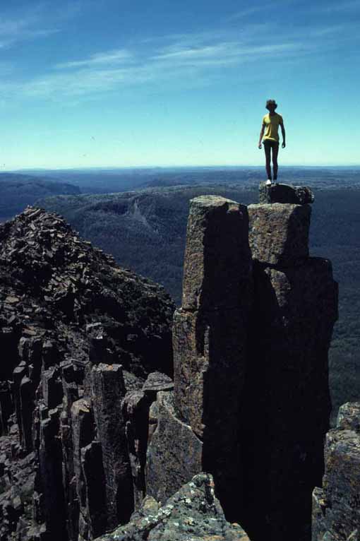
特にクレイドル山は、その構造そのものを溶かそうとしている基礎的な力に逆らうように見える岩層で覆われています。
〈http://www.david-noble.net/Tasmania/Reserve/Reserve.html〉
〈https://www.smh.com.au/ffximage/2007/10/02/CradleMountain_wideweb__470x313,0.jpg〉
ドレライトの直立した柱は、雨の中でイースター島の彫像のように立っています。
〈http://www.labyrinth.net.au/~tdp/images/cradle.jpg〉
標準的な鉱物学的研究が示しているような、玄武岩質溶岩は、多くの場合、垂直方向の亀裂に分裂する傾向がある円柱状の形態に侵食されていることがわかります。
凍結と解凍が交互に繰り返される山頂では、雨水が石の割れ目に浸透し、そこで凍結して膨張し、岩をスラブに押し離します。
〈https://www.smh.com.au/ffximage/2007/10/02/CradleMountain_wideweb__470x313,0.jpg〉
または、水は石の中で最も抵抗の少ない経路を見つけ、最終的に岩が崩壊するまで、垂直方向の亀裂をさらに深く刻みます。
アマゾンのテプイについての「今日の写真」では、多くの頂上には、抽象的な彫刻庭園のように見える岩層が豊富にあることが指摘されました。
〈http://www.rutahsa.com/MR-FlyTurt.jpg〉
石のポイント、管状の柵の茂み、複数の指を備えた隆起した円柱状の「手」は、風化が主な原因にはなり得ないことを示します。
侵食はどのように多くの層、鋭いエッジ、キノコ型のキャップ、細かいディテールを備えた積み重ねられた石の塔を残しましたか?
〈https://upload.wikimedia.org/wikipedia/commons/a/ac/Roraima_Rocks8.JPG〉
そのような形はずっと前に柔らかくなっているはずです。
クレイドル山は、信じられないほどの数の同様の奇妙なもので戴冠しました。
〈http://www.david-noble.net/Tasmania/Reserve/06jpg.jpg〉
この山自体は、南アメリカの山塊に非常によく似ているため、いとこになる可能性があります。
〈http://www.worldwander.com/bernal/tepui.jpg〉
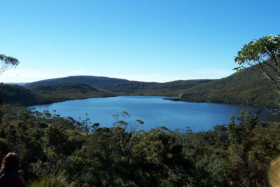
ダブ湖は、この地域に見られる多くの「火口湖」の1つです。
それは、岩盤からすくい出された、非常に深いお椀型の湖です。
〈http://www.john-daly.com/pics/dove_lake.jpg〉
湖の周りには垂直の崖があり、これはダブ湖が、実際には、直径数キロメートルの大きなクレーターの底です。
ウィリス湖は、ダブ湖の高いところにある別のボウル型の湖です。
そのオーバーフローは、壮大な滝としてダブ湖に流れ落ちます。
〈https://www.starsinsider.com/travel/452716/a-trek-through-tasmania〉
リラ湖、その他などのクレーターレイクは、形が似ています。
特に興味深い詳細は、これらの湖は、宇宙からの一種のショットガンの爆発によって作成されたようです。
それらは一緒にクラスター化され、ほぼ同じ形態を持ち、層に「パンチ」され、複数の層として表示されます。
オーストラリアの地形はどのようにして生まれましたか?
ライエルとアガシー以来教えられてきたことが正しければ、それらは、氷河、火山活動、侵食、その他のゆっくりとした、安定した、予測可能な力によって形成されました。これらの力は、私たちの周りで常に目に見えない形で発生しているはずです。
しかし、惑星の瘢痕化に関する電気的宇宙の仮説が正しければ、それらは瞬時にそして最近作成されたかもしれません。
スティーブン・スミス
――――――――
Apr 22, 2013
Could the dolerite structures in Tasmania be electrical formations?
タスマニアのドレライト(粗粒玄武岩)構造は電気層である可能性がありますか?
The Island of Tasmania in the south of Australia is one of the most provocative spots on Earth.
オーストラリア南部のタスマニア島は、地球上で最も挑発的なスポットの1つです。
〈http://www.about-australia.com/facts/tasmania/history/〉
The remarkable diversity of plant life and the unique animals found nowhere else have provided scientists of every stripe with near-ideal conditions for study.
植物の驚くべき多様性と他では見られないユニークな動物は、あらゆる分野の科学者達に、研究にほぼ理想的な条件を提供してきました。
The ecology is isolated, with little incursion from transplanted animals, although the rats that stowed away on early ships and the cats that were subsequently imported to kill the rats have had a dramatic (and sometime devastating) impact on the native animals.
このエコロジーは、初期の船に積み込まれたネズミと、その後ネズミを殺すために輸入されたネコは、在来の動物に劇的な(そして時には壊滅的な)影響を与えましたが、移植された動物からの侵入はほとんどありませんでした。
Cradle Mountain might qualify as another example of the mysterious stone monoliths that are found on every continent (and under the sea).
クレイドル山は、すべての大陸(および海の下)で見られる神秘的な石のモノリスの別の例として適格である可能性があります。
Unlike other Australian formations that are composed entirely of sandstone and a loose conglomerate of quartzite, sandstone, seashells and a collection of whatever minerals are found in the surrounding area, Cradle Mountain is a solid chunk of dolerite, or congealed basalt lava.
他のオーストラリアのフォーメーションとは異なり、クレイドル山は、完全に砂岩と、珪岩、砂岩、貝殻の緩い集合体、および周辺地域で見つかったあらゆる鉱物のコレクションで構成されており、ドレライトの固い塊、または凝結した玄武岩溶岩です。
〈http://thunderbolts.info/tpod/2007/arch07/071017bigthree.htm〉
Tasmania illustrates violent geologic activity that took place “millions of years ago” according to conventional models.
タスマニアは、従来のモデルによると、「数百万年前」に発生した激しい地質学的活動を示しています。
The mountainous uplifts, the deep, steep-sided gorges, the “needles” of stone that rise out of the ocean around its circumference and the many crater lakes found in the interior are said to be the remains of volcanic eruptions due to the movement of tectonic plates.
山岳の隆起、深く急な側面の峡谷、石の「針」は、周囲の海から浮かび上がるものや、内部に見られる多くの火口湖は、プレートの動きによる火山噴火の跡と言われています。
〈https://www.abebooks.co.uk/book-search/title/needles-of-stone/author/graves-tom/〉
Indeed, lava flows that buried valleys and snuffed-out jungles and forests are easy to see.
確かに、谷を埋め、ジャングルや森を消し去った溶岩流は見やすいです。
The difficulty with the observation is that the features appear to be exceptionally fresh rather than extremely ancient.
観察の難しさは、その特徴は非常に古いというよりも非常に新鮮に見えることです。
How do sharp needles of stone and vertical cliffs enclosing flat-bottomed channels come to exist through the slow process of erosion?
どの様に、平底の水路を囲む石の鋭い針と垂直の崖は、侵食の遅いプロセスを通して存在するようになったのでしょうか?
〈https://nla.gov.au/nla.obj-159100313/view〉
As most geologists propose, the erosive action of wind and rain tends to “melt” rock formations because rainwater is a weak form of carbonic acid and wind carries grains of dust that grind away at the stone over eons of time.
ほとんどの地質学者が提案するには、風と雨の侵食作用は岩層を「溶かす」傾向があります、雨水は炭酸の弱い形態であり、風は塵の粒を運び、それは何年にもわたって石で砕かれます。
Sharp points become blunted mounds;
vertical walls become gently sloping hills, while river valleys mature from canyons into shallow meanders in a broad flood plain.
鋭い先端は鈍い塚になります;
垂直の壁はなだらかに傾斜した丘になり、川の谷は峡谷から広い氾濫原の浅い蛇行に成熟します。
It is counter-intuitive, therefore, to find youthful topography in a location that should have matured into old age millennia ago.
したがって、ある場所で若々しい地形を見つけることは直感に反します、それは何千年も前に老年期に成熟したはずです。
Cradle Mountain, in particular, is crowned with rock formations that seem to defy the elemental forces that are attempting to dissolve its very structure.
特にクレイドル山は、その構造そのものを溶かそうとしている基礎的な力に逆らうように見える岩層で覆われています。
〈http://www.david-noble.net/Tasmania/Reserve/Reserve.html〉
〈https://www.smh.com.au/ffximage/2007/10/02/CradleMountain_wideweb__470x313,0.jpg〉
Upright columns of dolerite stand like Easter Island statues in the rain.
ドレライトの直立した柱は、雨の中でイースター島の彫像のように立っています。
〈http://www.labyrinth.net.au/~tdp/images/cradle.jpg〉
As standard mineralogical studies seem to indicate, basaltic lavas are often found eroded into columnar forms with a tendency to split into vertical fractures.
標準的な鉱物学的研究が示しているような、玄武岩質溶岩は、多くの場合、垂直方向の亀裂に分裂する傾向がある円柱状の形態に侵食されていることがわかります。
On mountain peaks that are exposed to alternate freezing and thawing, the rainwater supposedly seeps into cracks in the stone where it freezes and expands, forcing the rock apart into slabs.
凍結と解凍が交互に繰り返される山頂では、雨水が石の割れ目に浸透し、そこで凍結して膨張し、岩をスラブに押し離します。
〈https://www.smh.com.au/ffximage/2007/10/02/CradleMountain_wideweb__470x313,0.jpg〉
Or, water finds the path of least resistance in the stone, carving vertical cracks ever deeper until, eventually, the rock falls apart.
または、水は石の中で最も抵抗の少ない経路を見つけ、最終的に岩が崩壊するまで、垂直方向の亀裂をさらに深く刻みます。
In a Picture of the Day about the tepuis of Amazonia, it was noted that on many of the summits rock formations that look more like abstract sculpture gardens are abundant.
アマゾンのテプイについての「今日の写真」では、多くの頂上には、抽象的な彫刻庭園のように見える岩層が豊富にあることが指摘されました。
〈http://www.rutahsa.com/MR-FlyTurt.jpg〉
Stone points, thickets of tubular palisades and upraised, columnar “hands” with multiple fingers demonstrate that weathering cannot be the primary cause.
石のポイント、管状の柵の茂み、複数の指を備えた隆起した円柱状の「手」は、風化が主な原因にはなり得ないことを示します。
How does erosion leave behind stacked stone towers with many layers, sharp edges, mushroom-shaped caps and fine detail?
侵食はどのように多くの層、鋭いエッジ、キノコ型のキャップ、細かいディテールを備えた積み重ねられた石の塔を残しましたか?
〈https://upload.wikimedia.org/wikipedia/commons/a/ac/Roraima_Rocks8.JPG〉
Figures such as those should have softened long ago.
そのような形はずっと前に柔らかくなっているはずです。
Cradle Mountain is crowned with an incredible number of similar oddities.
クレイドル山は、信じられないほどの数の同様の奇妙なもので戴冠しました。
〈http://www.david-noble.net/Tasmania/Reserve/06jpg.jpg〉
The mountain, itself, resembles the South American massifs so closely that they could be cousins.
この山自体は、南アメリカの山塊に非常によく似ているため、いとこになる可能性があります。
〈http://www.worldwander.com/bernal/tepui.jpg〉
Dove Lake is one of many such “crater lakes” that can be found in the region.
ダブ湖は、この地域に見られる多くの「火口湖」の1つです。
It is a bowl-shaped lake, very deep, scooped out of the bedrock.
それは、岩盤からすくい出された、非常に深いお椀型の湖です。
〈http://www.john-daly.com/pics/dove_lake.jpg〉
Around the lake are vertical cliffs that seem to indicate that Dove Lake is actually the bottom of a larger crater that is several kilometers in diameter.
湖の周りには垂直の崖があり、これはダブ湖が、実際には、直径数キロメートルの大きなクレーターの底です。
Lake Willis is another bowl-shaped lake located high above Dove Lake.
ウィリス湖は、ダブ湖の高いところにある別のボウル型の湖です。
Its overflow runs down into Dove Lake as a spectacular waterfall.
そのオーバーフローは、壮大な滝としてダブ湖に流れ落ちます。
〈https://www.starsinsider.com/travel/452716/a-trek-through-tasmania〉
Crater Lake, Lake Lilla and others are similar in shape.
リラ湖、その他などのクレーターレイクは、形が似ています。
A particularly interesting detail is that these lakes appear to have been created by a kind of shotgun blast from space.
特に興味深い詳細は、これらの湖は、宇宙からの一種のショットガンの爆発によって作成されたようです。
They are clustered together, have nearly identical morphology and are “punched” into the strata, leaving it visible as multiple layers.
それらは一緒にクラスター化され、ほぼ同じ形態を持ち、層に「パンチ」され、複数の層として表示されます。
How did the Australian landforms come to be?
オーストラリアの地形はどのようにして生まれましたか?
If what has been taught since Lyell and Agassiz is correct, they were formed by glaciers, volcanism, erosion and other slow, steady, predictable forces that are supposed to be occurring invisibly all around us all the time.
ライエルとアガシー以来教えられてきたことが正しければ、それらは、氷河、火山活動、侵食、その他のゆっくりとした、安定した、予測可能な力によって形成されました。これらの力は、私たちの周りで常に目に見えない形で発生しているはずです。
But if the Electric Universe hypothesis of planetary scarring is correct, they might have been created in an instant and in the recent past.
しかし、惑星の瘢痕化に関する電気的宇宙の仮説が正しければ、それらは瞬時にそして最近作成されたかもしれません。
Stephen Smith
スティーブン・スミス