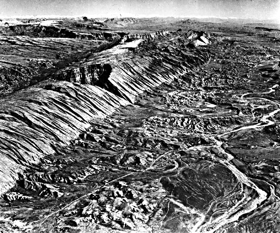
[The Zagros Mountains, Iran イランのザグロス山脈]

The small town of Konari, Iran and the Mand River.
イランのコナリとマンド川の小さな町。
――――――――
Oct 01, 2007
標準的な理論によれば、この驚くべき画像で観察された特徴を説明できる力は、風と水だけです。 電気が役割を果たしたのでしょうか?
地球の電気的瘢痕に関するこれまでの観察では、パタゴニア、シップロック、ニューメキシコ、ビクトリア湖、ブラントベルク山塊の山々はすべて、放電加工(EDM)によく似た特徴を示しています。
〈https://takaakifukatsu.hatenablog.jp/entry/2021/04/26/210618〉
〈https://takaakifukatsu.hatenablog.jp/entry/2021/09/26/005623〉
〈https://takaakifukatsu.hatenablog.jp/entry/2021/09/25/183650〉
〈https://takaakifukatsu.hatenablog.jp/entry/2021/09/21/102438〉
地球上で考えられる放電加工(EDM)の最も劇的な例の1つは、ザグロス山脈として知られるイラン南西部の地域です。
〈https://ja.wikipedia.org/wiki/%E3%82%B6%E3%82%B0%E3%83%AD%E3%82%B9%E5%B1%B1%E8%84%88〉
人間の居住の証拠は、新石器時代からそこに発見されています。
山岳国の高さは最大7000メートルですが、世界中の考古学チームは、それ自体が人類の歴史とほぼ同じくらい長い間、貿易と政治的支配の主要な中心地であったことを示しています。
スーサとチョガミッシュは、農業と金融の地区として地域全体にとって重要な2つの都市である現代のフーゼスターン(フージスターン州)で発掘されました。
〈https://maps.app.goo.gl/TwJfXf2GsQU2YS5V8〉
米国地質調査所(USGS)が運用するLandsat-7人工衛星は、1972年に最初に宇宙に上った前任者の手綱を引き継いで、長年にわたって地球の資源と史跡をマッピングしてきました。
〈https://landsat.usgs.gov/index.php/node/2〉
たとえば、Landsat-5は、地球の125,000番目の軌道周回を完了したばかりです。
以前の記事の多くは、Landsatシリーズによって提供された情報を利用しています。
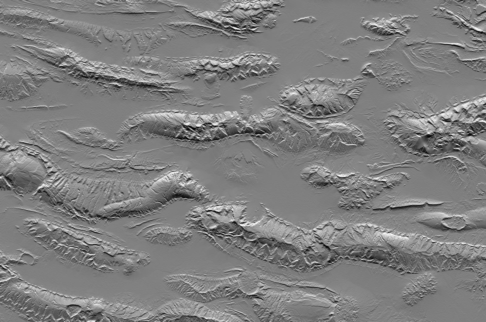
ザグロス山脈の地域には、何百マイルにも及ぶ巨大なV字型の尾根があります。
〈https://wikimili.com/en/Zagros_Mountains〉
それらはあらゆる規模で現存しており、山脈の固い岩にきれいに切り込まれています。
ページ上部の画像では、そのような特徴が谷底から立ち上がって、幅数百マイルの弧を描く多角形の階段の規則的なタイルのようなパターンで見られます。
山岳隆起の中には、巨大な力によって半分にカットされたクレーターのように見える半球形があります。
〈https://photojournal.jpl.nasa.gov/jpeg/PIA04956.jpg〉
ザグロス山脈は、それ自体が例外的な地層であり、プラスチック(可塑性)の岩のように山からにじみ出る「岩塩氷河」など、その独特の性質が報告されています。
しかしながら、イランとほぼ同じ等高線を表示する地球上の他の領域があります。
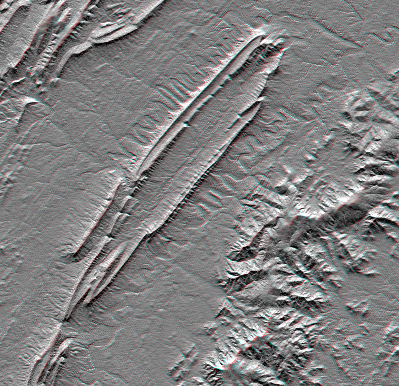
バージニア州のマッサヌッテン山とユタ州のサンラファエル・スウェルには、それぞれ特徴的な二重の尾根の谷と、イランで見られるリッチェンバーグ(リヒテンベルク)図形が放射状に広がる弧状の岬があります。
〈https://photojournal.jpl.nasa.gov/jpeg/PIA03382.jpg〉
〈http://www.13ergirl.com/IMG_0086mod.jpg〉
それらは巨大な山形のブロックで構成されており、火山活動によって成形されたり、風雨によって侵食されたりするのではなく、彫られたものであることを示唆しています。
〈https://disc.gsfc.nasa.gov/geomorphology/GEO_2/geo_images_T-42/FigT-42.7.jpeg〉
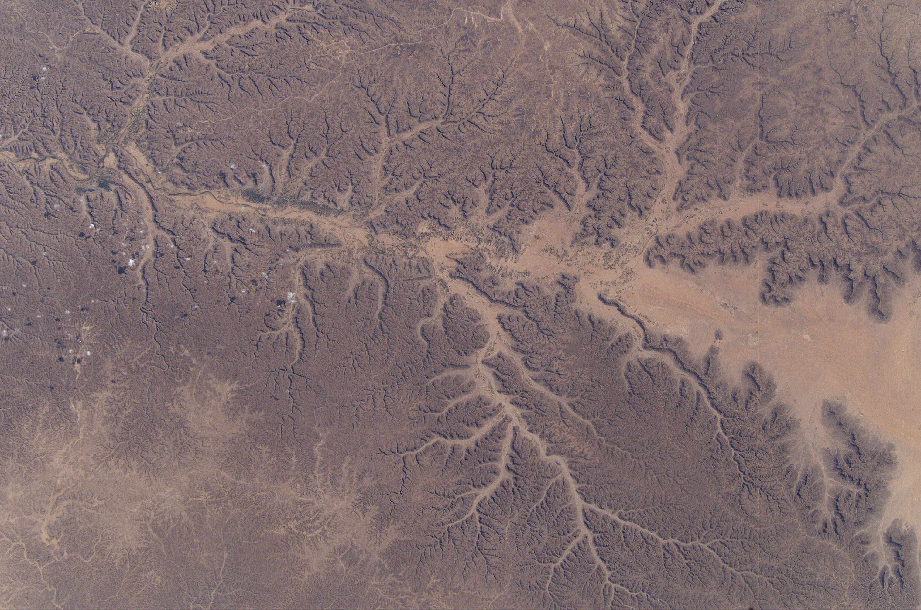
より適切なのは、ザグロス山脈がイエメン南部に切り込んだ巨大な放電路に近接していることです。
〈https://solarviews.com/huge/earth/yemen.jpg〉
マッサヌッテン山の場合、大西洋がチェサピークの傷跡を占めていることを除いて、チェサピーク湾は全体的な構成が実質的に同じですが、イエメンの湾はその手付かずの外観を保持しています。
〈https://ja.wikipedia.org/wiki/%E3%83%81%E3%82%A7%E3%82%B5%E3%83%94%E3%83%BC%E3%82%AF%E6%B9%BE〉
イエメンとバージニアはどちらも、ゼウス自身が投げたものと同じ大きさの稲妻に見舞われたように見えます。
同じ宇宙のサンダーボルトがザグロス山脈の掘削と彫刻を担って居ましたか?
〈http://geoinfo.amu.edu.pl/wpk/geos/GEO_2/geo_images_T-42/FigT-42.4.jpeg〉
By Stephen Smith
スティーブン・スミス
――――――――
Oct 01, 2007
According to standard theory, wind and water are the only forces that can explain the features observed in this startling image. Could electricity have played a role?
標準的な理論によれば、この驚くべき画像で観察された特徴を説明できる力は、風と水だけです。 電気が役割を果たしたのでしょうか?
In our previous observations of the Earth's electrical scarring, the mountains of Patagonia, Shiprock, New Mexico, Lake Victoria and the Brandberg Massif all reveal features that closely resemble electric discharge machining, or EDM.
地球の電気的瘢痕に関するこれまでの観察では、パタゴニア、シップロック、ニューメキシコ、ビクトリア湖、ブラントベルク山塊の山々はすべて、放電加工(EDM)によく似た特徴を示しています。
〈https://takaakifukatsu.hatenablog.jp/entry/2021/04/26/210618〉
〈https://takaakifukatsu.hatenablog.jp/entry/2021/09/26/005623〉
〈https://takaakifukatsu.hatenablog.jp/entry/2021/09/25/183650〉
〈https://takaakifukatsu.hatenablog.jp/entry/2021/09/21/102438〉
One of the most dramatic examples of possible EDM on Earth is an area in southwestern Iran known as the Zagros mountains.
地球上で考えられる放電加工(EDM)の最も劇的な例の1つは、ザグロス山脈として知られるイラン南西部の地域です。
〈https://ja.wikipedia.org/wiki/%E3%82%B6%E3%82%B0%E3%83%AD%E3%82%B9%E5%B1%B1%E8%84%88〉
Evidence of human habitation has been found there from as early as the Neolithic period.
人間の居住の証拠は、新石器時代からそこに発見されています。
Archaeological teams from around the world have shown it to have been a major center of trade and political dominance for nearly as long as human history, itself, though the mountainous country is up to seven thousand meters high.
山岳国の高さは最大7000メートルですが、世界中の考古学チームは、それ自体が人類の歴史とほぼ同じくらい長い間、貿易と政治的支配の主要な中心地であったことを示しています。
Susa and Chogha Mish have been unearthed in modern Khuzestan, two cities that were important to the entire region as agricultural and financial districts.
スーサとチョガミッシュは、農業と金融の地区として地域全体にとって重要な2つの都市である現代のフーゼスターン(フージスターン州)で発掘されました。
〈https://maps.app.goo.gl/TwJfXf2GsQU2YS5V8〉
The Landsat-7 satellite, operated by the United States Geological Survey (USGS), has been mapping the Earth's resources and historical sites for many years taking the reins from its predecessors that first went up to space in 1972.
米国地質調査所(USGS)が運用するLandsat-7人工衛星は、1972年に最初に宇宙に上った前任者の手綱を引き継いで、長年にわたって地球の資源と史跡をマッピングしてきました。
〈https://landsat.usgs.gov/index.php/node/2〉
Landsat-5, for example, has just completed its 125 thousandth orbit of the Earth.
たとえば、Landsat-5は、地球の125,000番目の軌道周回を完了したばかりです。
Many of our previous articles have made use of information provided by the Landsat series.
以前の記事の多くは、Landsatシリーズによって提供された情報を利用しています。
Found in the region of the Zagros mountains are gigantic V-shaped ridges that extend for hundreds of miles.
ザグロス山脈の地域には、何百マイルにも及ぶ巨大なV字型の尾根があります。
〈https://wikimili.com/en/Zagros_Mountains〉
They are extant at every scale and are cleanly cut into the solid rock of the mountain range.
それらはあらゆる規模で現存しており、山脈の固い岩にきれいに切り込まれています。
In the image at the top of the page such features can be seen rising up from the valley floor in regular, tile-like patterns of polygonal steps each one describing an arc several hundred miles wide.
ページ上部の画像では、そのような特徴が谷底から立ち上がって、幅数百マイルの弧を描く多角形の階段の規則的なタイルのようなパターンで見られます。
Within the mountainous uplifts are hemispherical shapes that appear to be craters cut in half by titanic forces.
山岳隆起の中には、巨大な力によって半分にカットされたクレーターのように見える半球形があります。
〈https://photojournal.jpl.nasa.gov/jpeg/PIA04956.jpg〉
In and of themselves, the Zagros mountains are exceptional geological formations that have been under reported for their distinctive nature, such as the "salt glaciers" that ooze from the mountain like plastic rock.
ザグロス山脈は、それ自体が例外的な地層であり、プラスチック(可塑性)の岩のように山からにじみ出る「岩塩氷河」など、その独特の性質が報告されています。
However, there are other areas on Earth that display contours almost identical to those in Iran.
しかしながら、イランとほぼ同じ等高線を表示する地球上の他の領域があります。
Massanutten mountain, Virginia and the San Rafael Swell, Utah, each possess the characteristic dual-ridge valleys and arc-shaped headlands with radiating Lichtenberg figures seen in Iran.
バージニア州のマッサヌッテン山とユタ州のサンラファエル・スウェルには、それぞれ特徴的な二重の尾根の谷と、イランで見られるリッチェンバーグ(リヒテンベルク)図形が放射状に広がる弧状の岬があります。
〈https://photojournal.jpl.nasa.gov/jpeg/PIA03382.jpg〉
〈http://www.13ergirl.com/IMG_0086mod.jpg〉
They are composed of giant, chevron-shaped blocks that suggest they were carved rather than molded by volcanism or eroded by wind and rain.
それらは巨大な山形のブロックで構成されており、火山活動によって成形されたり、風雨によって侵食されたりするのではなく、彫られたものであることを示唆しています。
〈https://disc.gsfc.nasa.gov/geomorphology/GEO_2/geo_images_T-42/FigT-42.7.jpeg〉
More relevant is the proximity of the Zagros mountain range to the huge discharge trackway that has cut into southern Yemen.
より適切なのは、ザグロス山脈がイエメン南部に切り込んだ巨大な放電路に近接していることです。
〈https://solarviews.com/huge/earth/yemen.jpg〉
In the case of Massanutten mountain, Chesapeake Bay is practically identical in overall configuration, except that the Atlantic Ocean has occupied the scar of Chesapeake, while the one in Yemen retains its pristine appearance.
マッサヌッテン山の場合、大西洋がチェサピークの傷跡を占めていることを除いて、チェサピーク湾は全体的な構成が実質的に同じですが、イエメンの湾はその手付かずの外観を保持しています。
〈https://ja.wikipedia.org/wiki/%E3%83%81%E3%82%A7%E3%82%B5%E3%83%94%E3%83%BC%E3%82%AF%E6%B9%BE〉
Both Yemen and Virginia look like they were hit by lightning bolts as big as those cast by Zeus himself.
イエメンとバージニアはどちらも、ゼウス自身が投げたものと同じ大きさの稲妻に見舞われたように見えます。
Are the same cosmic thunderbolts responsible for excavating and sculpting the Zagros Mountains?
同じ宇宙のサンダーボルトがザグロス山脈の掘削と彫刻を担って居ましたか?
〈http://geoinfo.amu.edu.pl/wpk/geos/GEO_2/geo_images_T-42/FigT-42.4.jpeg〉
By Stephen Smith
スティーブン・スミス