ザ・サンダーボルツ勝手連 [The Mountains of Patagonia パタゴニアの山々]
[The Mountains of Patagonia パタゴニアの山々]

―――――――
Jun 27, 2007
山の隆起に関する長年の理論は、私たちがよく観察する高くそびえる垂直の特徴を適切に説明したことは一度もありません。しかし、研究者達が電気力の可能な役割を考えると、状況は変わります。
アルゼンチン南部は壮観です。
実際、南アメリカ大陸全体が極端な地形に支配されています;
溶岩原、砂漠、鋭い山頂、クレーター。
〈http://209.35.123.177/americas/AmpatoVolcano.jpg〉
〈http://esamultimedia.esa.int/images/envisat/Chile_Atacama_MER_FR_Orbit04516_20030110.jpg〉
〈https://www.granitefilms.com/gallery/images/climbing/CerroTorre%26Glacier.jpg〉
〈https://www.google.com/maps/place/23%C2%B056'00.0%22S+68%C2%B017'00.0%22W/@-23.9348,-68.289299,12z/data=!3m1!1e3?hl=en〉
この地域がこのような珍しい地形をどのように発達させたかについては多くの理論があり、そのほとんどは長期的な火山活動と氷河の洗掘に基づいています。
しかしながら、そのような地形のいくつかの例は、火星や他の惑星天体で画像化されています。
〈http://www.msss.com/mars_images/moc/merid3d_6_2001/meridiani_FHA-E04_50perc.jpg〉
〈http://abyss.uoregon.edu/~js/images/miranda6.gif〉
それは、それらがどこにあるかに関係なく、同様の形成プロセスを示唆しているでしょうか?
従来の地質学用語では、パタゴニアは、数億年とまではいかなくても、数百万年前の風景を展示しています。
〈https://www.answers.com/redirectSearch〉
上に示したフィッツロイとセロトーレの山頂は、大陸の継続的な褶曲と圧縮によって引き起こされる広範な隆起層の一部です。
著者として、マリオリーナとジョルジオ・アルドリッツィは次のように書いています:
〈http://www.capehorn-pilot.com/pagine/The%20Authors%20in%20English.htm〉
「学者達は、現在パタゴニアのフィヨルドやティエラデルフエゴのフィヨルドに沿って見られるような断片化された地理の起源は、4つの主な要因に帰することができると信じています:
1.
海洋プレートと大陸棚の出会い;
2.
複雑な外因性の現象、特に第三紀以前の期間に起こった水による侵食;
3.
過去200万年に始まり、14、000年前に最後の氷河期で終わった激しい氷河期;
4.
複雑な地質学的現象、特に緩慢地動や地震、それは、何キロも上った古代の谷への海の水の侵入を開く地面の陥没を作りました。」
しかしながら、特徴の古さを疑問視するいくつかの特性があります。
地形の多くには、出口のない湖に流れ込む川が含まれています。
〈https://photojournal.jpl.nasa.gov/jpeg/PIA02760.jpg〉
湖がそのような古代の地理の一部である場合、なぜ、それらは彼らを取り巻く侵食された山脈からの破片で満たされなかったのですか?
セロトーレなどの山脈は玄武岩で構成されています。
それらは溶岩流が数千平方キロメートルを飲み込んだときに形成され、中には9千メートル以上の厚さに達するものもありました。
標準的な形成理論では、山に刻まれた谷の段々になった側面を説明できません。
それらのいくつかは、鋭く尖った中央のピークを含む半球形のブラインドキャニオンです。
山頂は峡谷の壁と同じようにテラスに刻まれていますが、これも説明が非常に難しい属性です。
鋭い「火山」ピークは、キャニオンウォールと同じ種類の主張を実証することができますか?
繰り返しになりますが、侵食された溶岩からの破片は残っていないようです。
この谷と峡谷の深さは数千メートルですが、しかし、距骨の傾斜は非常に小さく、谷底には岩がなく、砂利や氷河のモレーンの巨大な山は見られません。
侵食された物質達はどこに行ったのですか?
玄武岩の断崖のもう1つの珍しい特徴は、尾根の上部に切り込まれたポットホール型のくぼみです。
〈https://photojournal.jpl.nasa.gov/jpeg/PIA02762.jpg〉
穴には水が入っていますが、そこに水を供給する川がなく、出口もありません。
春には融雪で埋められる可能性が高いですが、縁ははっきりと定義されており、風や水によって侵食されているようには見えません。
それらの構造のもう一つの珍しい側面は、それらを横切る洗掘跡です。
〈https://photojournal.jpl.nasa.gov/jpeg/PIA02766.jpg〉
放電加工は、1つの説明を提供することができます。
電気的理論家達によって構想された惑星の不安定性の歴史的な段階では、惑星は放電に飲み込まれました。
激しいアークの時代には、1兆キロワットの稲妻が岩を粉砕して気化し、それを宇宙に向かって持ち上げ、段々になった崖と深い穴を尾根に開けたままにしていた可能性があります。
そのような活動の焼き印(特徴)は、破片の欠如と滑らかな谷底です。
切除された物質は、工業用プラズマ表面の洗浄と同様のプロセスで除去されたはずです。
以前のサンダーボルトの「今日の写真」では、アラビア大陸、マリネリス峡谷、その他の建造物を切り開いた火星でのそのような出来事の理論を説明しました。
ここで、鋭く彫刻されたパタゴニアの山々を含む地球上の主要な特徴が、宇宙の落雷によって残された残骸であるかどうかを尋ねなければなりません。
スティーブン・スミス著
―――――――
Jun 27, 2007
Long-standing theories of mountain uplift have never adequately explained the towering vertical features we often observe. But the picture changes when researchers consider the possible role of the electric force.
山の隆起に関する長年の理論は、私たちがよく観察する高くそびえる垂直の特徴を適切に説明したことは一度もありません。しかし、研究者達が電気力の可能な役割を考えると、状況は変わります。
Southern Argentina is spectacular.
アルゼンチン南部は壮観です。
In fact, the entire South American continent is dominated by extreme topography;
lava fields, deserts, needle-sharp mountain peaks and craters.
実際、南アメリカ大陸全体が極端な地形に支配されています;
溶岩原、砂漠、鋭い山頂、クレーター。
〈http://209.35.123.177/americas/AmpatoVolcano.jpg〉
〈http://esamultimedia.esa.int/images/envisat/Chile_Atacama_MER_FR_Orbit04516_20030110.jpg〉
〈https://www.granitefilms.com/gallery/images/climbing/CerroTorre%26Glacier.jpg〉
〈https://www.google.com/maps/place/23%C2%B056'00.0%22S+68%C2%B017'00.0%22W/@-23.9348,-68.289299,12z/data=!3m1!1e3?hl=en〉
There are many theories about how the region developed such unusual terrain, most based on long-term volcanism and glacier scouring.
この地域がこのような珍しい地形をどのように発達させたかについては多くの理論があり、そのほとんどは長期的な火山活動と氷河の洗掘に基づいています。
However, several examples of such topography have been imaged on Mars and other planetary bodies.
しかしながら、そのような地形のいくつかの例は、火星や他の惑星天体で画像化されています。
〈http://www.msss.com/mars_images/moc/merid3d_6_2001/meridiani_FHA-E04_50perc.jpg〉
〈http://abyss.uoregon.edu/~js/images/miranda6.gif〉
Could that suggest a similar process of formation regardless of where they're found?
それは、それらがどこにあるかに関係なく、同様の形成プロセスを示唆しているでしょうか?
In conventional geological terms, Patagonia exhibits landscapes that are millions, if not hundreds of millions of years old.
従来の地質学用語では、パタゴニアは、数億年とまではいかなくても、数百万年前の風景を展示しています。
〈https://www.answers.com/redirectSearch〉
The Fitz Roy and Cerro Torre mountain peaks, shown above, are part of an extensive uplift formation caused by the continuous folding and compression of the continent.
上に示したフィッツロイとセロトーレの山頂は、大陸の継続的な褶曲と圧縮によって引き起こされる広範な隆起層の一部です。
As authors Mariolina and Giorgio Ardrizzi write:
著者として、マリオリーナとジョルジオ・アルドリッツィは次のように書いています:
〈http://www.capehorn-pilot.com/pagine/The%20Authors%20in%20English.htm〉
“Scholars believe that the origin of such a fragmented geography like that which can be seen at present along the Patagonian fjords and those of the Tierra del Fuego, can be put down to four main factors:
「学者達は、現在パタゴニアのフィヨルドやティエラデルフエゴのフィヨルドに沿って見られるような断片化された地理の起源は、4つの主な要因に帰することができると信じています:
1.
the meeting of the oceanic plate with the continental shelf;
海洋プレートと大陸棚の出会い;
2.
complex exogenous phenomena, especially of erosion by water that took place during the pre-Tertiary periods;
複雑な外因性の現象、特に第三紀以前の期間に起こった水による侵食;
3.
a period of intense glaciation, that started in the last 2 million years and ended 14,000 years ago with the last glaciation;
過去200万年に始まり、14、000年前に最後の氷河期で終わった激しい氷河期;
4.
complex geological phenomena, especially bradyseisms and earthquakes, which made the ground sink opening a breach to the waters of the ocean that went kilometres up the ancient valleys.”
複雑な地質学的現象、特に緩慢地動や地震、それは、何キロも上った古代の谷への海の水の侵入を開く地面の陥没を作りました。」
There are some characteristics that bring into question the age of the features, however.
しかしながら、特徴の古さを疑問視するいくつかの特性があります。
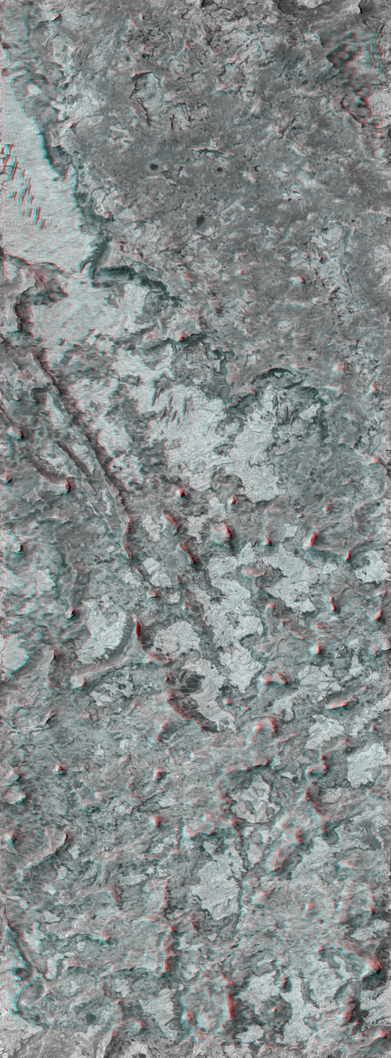
Many of the landforms include rivers that empty into lakes with no outlets.
地形の多くには、出口のない湖に流れ込む川が含まれています。
〈https://photojournal.jpl.nasa.gov/jpeg/PIA02760.jpg〉
If the lakes are part of such ancient geography, why have they not been filled-in with debris from the eroding mountain ranges that surround them?
湖がそのような古代の地理の一部である場合、なぜ、それらは彼らを取り巻く侵食された山脈からの破片で満たされなかったのですか?
The mountain ranges, such as Cerro Torre are composed of basalt.
セロトーレなどの山脈は玄武岩で構成されています。
They formed when lava flows engulfed thousands of square kilometers, some reaching over nine thousand meters thick.
それらは溶岩流が数千平方キロメートルを飲み込んだときに形成され、中には9千メートル以上の厚さに達するものもありました。
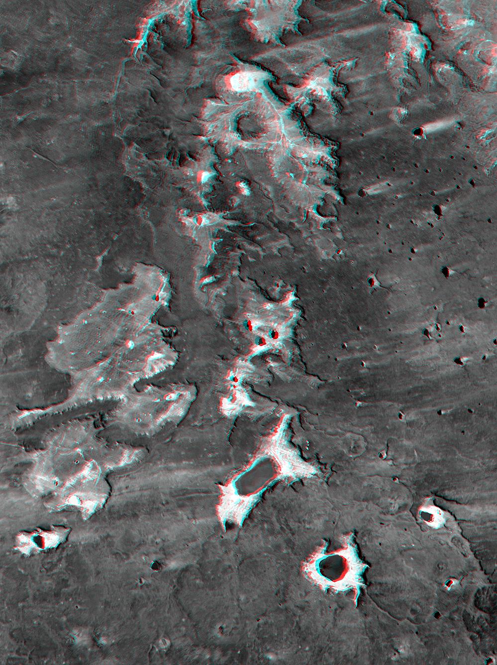
Standard theories of formation fail to explain the terraced flanks of the valleys carved into the mountains.
標準的な形成理論では、山に刻まれた谷の段々になった側面を説明できません。
Some of them are blind canyons with hemispherical shapes that contain sharply pointed central peaks.
それらのいくつかは、鋭く尖った中央のピークを含む半球形のブラインドキャニオンです。
The peaks are carved in terraces just like the canyon walls, another attribute that is very difficult to explain.
山頂は峡谷の壁と同じようにテラスに刻まれていますが、これも説明が非常に難しい属性です。
How can a sharp "volcanic" peak demonstrate the same kind of terracing as the canyon wall?
鋭い「火山」ピークは、キャニオンウォールと同じ種類の主張を実証することができますか?
Once again, there appears to be no debris remaining from the eroded lava.
繰り返しになりますが、侵食された溶岩からの破片は残っていないようです。
The valleys and canyons are thousands of meters deep, but the talus slopes are very small, there are no boulders on the valley floor, and no huge heaps of gravel or glacial moraines are apparent.
この谷と峡谷の深さは数千メートルですが、しかし、距骨の傾斜は非常に小さく、谷底には岩がなく、砂利や氷河のモレーンの巨大な山は見られません。
Where has all the eroded material gone?
侵食された物質達はどこに行ったのですか?
Another unusual feature of the basalt cliffs is the pothole shaped depressions incised into the top of the ridges.
玄武岩の断崖のもう1つの珍しい特徴は、尾根の上部に切り込まれたポットホール型のくぼみです。
〈https://photojournal.jpl.nasa.gov/jpeg/PIA02762.jpg〉
The holes contain water, but they have no rivers feeding them and they have no outlets.
穴には水が入っていますが、そこに水を供給する川がなく、出口もありません。
Although they are most likely filled in spring by snowmelt, their rims are sharply defined and do not appear to be eroded by wind or water.
春には融雪で埋められる可能性が高いですが、縁ははっきりと定義されており、風や水によって侵食されているようには見えません。
Another unusual aspect to their structure is the scour marks that cross over them.
それらの構造のもう一つの珍しい側面は、それらを横切る洗掘跡です。
〈https://photojournal.jpl.nasa.gov/jpeg/PIA02766.jpg〉
Electric discharge machining could provide an explanation.
放電加工は、1つの説明を提供することができます。
In the historic phase of planetary instability envisioned by electrical theorists, planets were engulfed by electric discharge.
電気的理論家達によって構想された惑星の不安定性の歴史的な段階では、惑星は放電に飲み込まれました。
In periods of intense arcing a trillion kilowatt bolt of lightning could have shattered and vaporized the rock, lofting it toward space, leaving the terraced cliffs and deep holes bored into the ridges.
激しいアークの時代には、1兆キロワットの稲妻が岩を粉砕して気化し、それを宇宙に向かって持ち上げ、段々になった崖と深い穴を尾根に開けたままにしていた可能性があります。
A hallmark of such activity would be the lack of debris and the smooth valley floors.
そのような活動の焼き印(特徴)は、破片の欠如と滑らかな谷底です。
The excised material would have been removed in a process akin to industrial plasma surface cleaning.
切除された物質は、工業用プラズマ表面の洗浄と同様のプロセスで除去されたはずです。
Previous Thunderbolt Pictures of the Day have described theories of such events on Mars that carved out Arabia Terra, Valles Marineris and other structures.
以前のサンダーボルトの「今日の写真」では、アラビア大陸、マリネリス峡谷、その他の建造物を切り開いた火星でのそのような出来事の理論を説明しました。
Now we must ask whether major features on Earth, including the sharply sculpted mountains of Patagonia, are remnants left by cosmic thunderbolts.
ここで、鋭く彫刻されたパタゴニアの山々を含む地球上の主要な特徴が、宇宙の落雷によって残された残骸であるかどうかを尋ねなければなりません。
By Stephen Smith
スティーブン・スミス著