ザ・サンダーボルツ勝手連 [Lake Victoria ビクトリア湖]
[Lake Victoria ビクトリア湖]

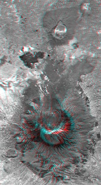
Lake Victoria from space.
宇宙からのビクトリア湖。
――――――――
Aug 10, 2007
ビクトリア湖は、地球上で最大の電気形成の1つである可能性があります。 湖の周りには、他の惑星や月衛星に見られるものと同様のいくつかの円形の構造物やその他の特徴があります。
この地域(およびアフリカの他の地域)の地理は、電気の影響を強く示唆しています。
他のThunderbolts 「今日の写真」の記事では、アフリカの多くの特徴が表面を掘削し、今日見られるものを形成するプラズマアークの結果であることを示す証拠が提示されました。
〈https://takaakifukatsu.hatenablog.jp/entry/2021/09/21/102438〉
〈https://takaakifukatsu.hatenablog.jp/entry/2021/08/22/185811〉
ブラントベルク山塊、ケビラクレーター、リシャット構造などは、太陽系の歴史の初期の電気的にアクティブな段階での放電加工(EDM)による傷跡である可能性が非常に高いです。
〈https://takaakifukatsu.hatenablog.jp/entry/2021/07/16/221550〉
これらの地層をより綿密に調査したところ、同じ種類の力がビクトリア湖の作成にも役立ったようです。
プレートテクトニクスの従来の地質学理論では、大陸は地殻の数マイル下の溶融岩の層に浮かんでいます。
〈https://ucmp.berkeley.edu/geology/tectonics.html〉
マグマの密度が高く、大陸の岩石の密度が低いため、マグマは惑星の表面を動き回ることができ、衝突したり、引き離したりすることがあります。
「沈み込み帯」と呼ばれる広大な地域は、堆積岩の巨大なブロックを熱い内部に引き込み、そこでマグマに溶け込みます。
メルトゾーンの上の地殻ブロックが熱くなると、火山が形成され、沈み込んだ海底堆積物が溶岩の形で陸地に噴出し、破壊と再形成のサイクルを生み出します。
支配的な理論は、沈み込みを引き起こすのと同じ力が海底や惑星の周りの他の領域をひび割れて広げ、新しい地殻を形成しているために、グレートリフトが生じたと主張しています。
〈https://kotobank.jp/word/%E3%82%A2%E3%83%95%E3%83%AA%E3%82%AB%E5%A4%A7%E5%9C%B0%E6%BA%9D%E5%B8%AF-156387〉
マグマの熱バランスにおける巨大な対流のために、大陸の質量は離れて移動するだけでなく、一緒に衝突します。
リフトバレー周辺には、ケニア山やキリマンジャロ山など、アフリカと世界で最大の火山があります。
〈http://www.mountkenyaexpeditions.com/images/mtkenyaclimb.jpg〉
〈http://earth.imagico.de/views/kilimanjaro2_large.jpg〉
いくつかは死火山に成っていて、大部分は何百年もの間噴火していません。
それらはすべて、地質学者が「楯状火山」と呼んでいるものを表しており、マグマが異常に表面に近く、特に高温の場所に発生します。
〈https://kotobank.jp/word/%E6%A5%AF%E7%8A%B6%E7%81%AB%E5%B1%B1-93708〉
キリマンジャロ山と他の火山は、実際には複数の火山であり、より大きな構造に統合されています。
ハワイの長い裂罅(れっか)火山と同様に、最初の噴火が起こった山頂の下には非常に大きな裂罅(れっか)があります。
それらのアフリカの山頂には、キリマンジャロ山、エルゴン山、メルー山などがあります。
〈https://photojournal.jpl.nasa.gov/jpeg/PIA04958.jpg〉
〈https://epod.usra.edu/〉
それらはすべて、ビクトリア湖を囲む二重尾根断層の上にあります。
〈http://neuropolitics.org/GreatRiftValley.gif〉
断層の非常に興味深い側面の1つは、アファール窪地の分岐点として始まり、西リフトバレーとしてループバックし、ビクトリア湖を形成してから、マラウイ湖が埋め尽くす南に移動することです。
〈http://earth.imagico.de/views/ethiopia_large.jpg〉
〈http://earth.imagico.de/views/kenya_large.jpg〉
〈https://youtu.be/44EzcfpM5tk〉
メル山の近くには、数百平方マイルをカバーする鋭くカットされた樹枝状の尾根または「リッチェンバーグ(リヒテンベルク)」図形があります。
〈https://photojournal.jpl.nasa.gov/jpeg/PIA03356.jpg〉
メル山自体は非常に珍しく、中央の山が鋭く尖った半火口(クレーター)です。
〈https://photojournal.jpl.nasa.gov/jpeg/PIA03358.jpg〉
パタゴニア山脈の記事では、火山の噴火が半火口(クレーター)の爆破された残骸に針の鋭いピークを残すことは決してないので、そのような地層は大きな電気アーク放電からの地層として提示されました。
〈https://takaakifukatsu.hatenablog.jp/entry/2021/04/26/210618〉
確かに、セントヘレンズ山はそのような玄武岩のモノリス(単岩)を残しませんでした。
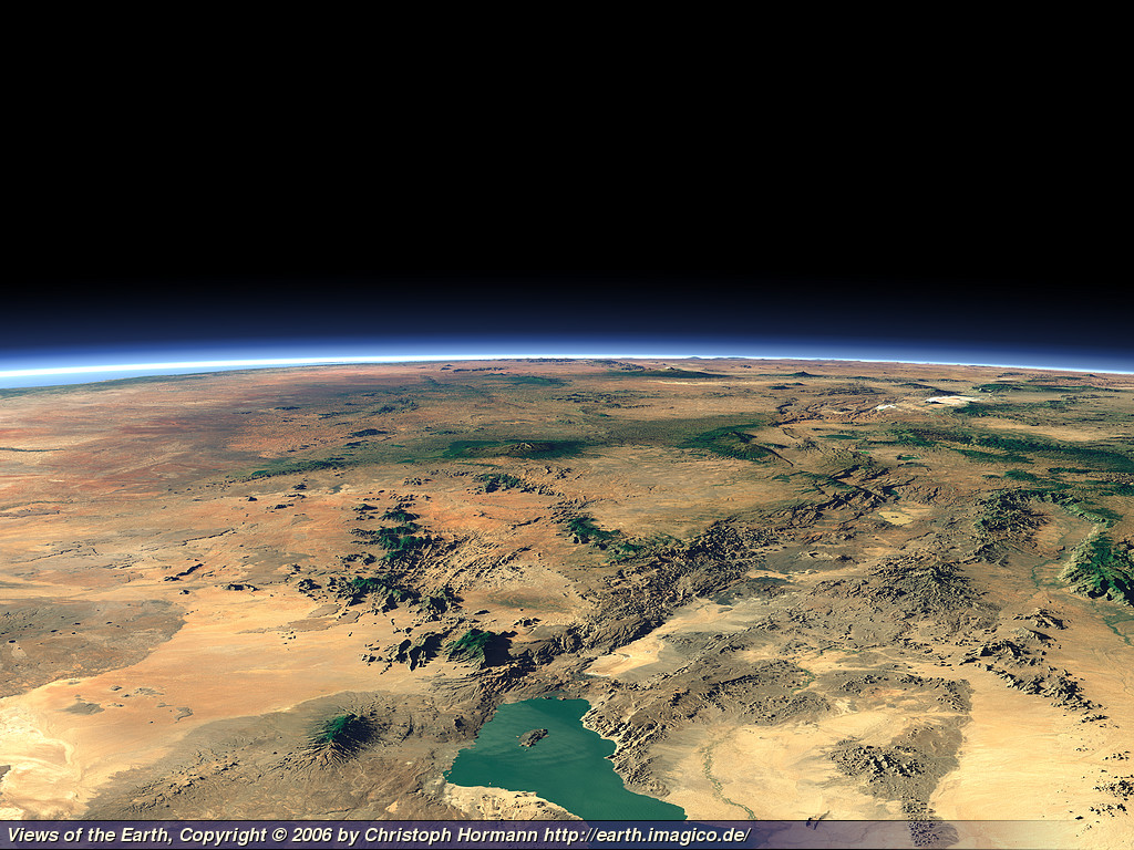
ビクトリア湖は、世界最大の火山に囲まれた深さ1 kmの海溝の真ん中にある円形の特徴であり、多くの場所で岩に刻まれた都市規模の稲妻の道のように見えます。
電気力が湖と地溝帯を作り出したと結論付けるのは、以前に説明した他の多くの大きな円形の特徴を生み出したのと同じように、より合理的と思われます。
スティーブ・スミス
――――――――
Aug 10, 2007
Lake Victoria may be among the largest electrical formations on Earth. Surrounding the lake are several circular structures and other features similar to those found on other planets and moons.
ビクトリア湖は、地球上で最大の電気形成の1つである可能性があります。 湖の周りには、他の惑星や月衛星に見られるものと同様のいくつかの円形の構造物やその他の特徴があります。
The geography in this area (and the rest of Africa) strongly suggests electrical influence.
この地域(およびアフリカの他の地域)の地理は、電気の影響を強く示唆しています。
In other Thunderbolts Picture of the Day articles, evidence was presented indicating that many features in Africa are the result of plasma arcs excavating the surface and forming what we see today.
他のThunderbolts 「今日の写真」の記事では、アフリカの多くの特徴が表面を掘削し、今日見られるものを形成するプラズマアークの結果であることを示す証拠が提示されました。
〈https://takaakifukatsu.hatenablog.jp/entry/2021/09/21/102438〉
〈https://takaakifukatsu.hatenablog.jp/entry/2021/08/22/185811〉
The Brandberg Massif, Kebira Crater, the Richat Structure and others could very well be the scars from electric discharge machining (EDM) in an earlier, electrically active phase of solar system history.
ブラントベルク山塊、ケビラクレーター、リシャット構造などは、太陽系の歴史の初期の電気的にアクティブな段階での放電加工(EDM)による傷跡である可能性が非常に高いです。
〈https://takaakifukatsu.hatenablog.jp/entry/2021/07/16/221550〉
As we have investigated these formations more closely, it appears that the same kind of power may have helped to create Lake Victoria, as well.
これらの地層をより綿密に調査したところ、同じ種類の力がビクトリア湖の作成にも役立ったようです。
In conventional geological theory of plate tectonics, the continents are floating on a layer of molten rock several miles beneath the Earth's crust.
プレートテクトニクスの従来の地質学理論では、大陸は地殻の数マイル下の溶融岩の層に浮かんでいます。
〈https://ucmp.berkeley.edu/geology/tectonics.html〉
The higher density of the magma and the lower density of the continental rock makes them able to move around on the face of the planet, sometimes colliding and sometimes pulling apart.
マグマの密度が高く、大陸の岩石の密度が低いため、マグマは惑星の表面を動き回ることができ、衝突したり、引き離したりすることがあります。
Huge areas called, "subduction zones" pull vast blocks of sedimentary rock down into the hot interior where they melt into the magma.
「沈み込み帯」と呼ばれる広大な地域は、堆積岩の巨大なブロックを熱い内部に引き込み、そこでマグマに溶け込みます。
As the crustal blocks above the melt zones heat up, volcanoes form and erupt the subducted seafloor sediments out onto the land in the form of lava, creating a cycle of destruction and reformation.
メルトゾーンの上の地殻ブロックが熱くなると、火山が形成され、沈み込んだ海底堆積物が溶岩の形で陸地に噴出し、破壊と再形成のサイクルを生み出します。
The prevailing theory claims that the Great Rift arose because the same force that causes subduction is also causing the ocean bottom and other areas around the planet to crack and spread apart, forming new crust.
支配的な理論は、沈み込みを引き起こすのと同じ力が海底や惑星の周りの他の領域をひび割れて広げ、新しい地殻を形成しているために、グレートリフトが生じたと主張しています。
〈https://kotobank.jp/word/%E3%82%A2%E3%83%95%E3%83%AA%E3%82%AB%E5%A4%A7%E5%9C%B0%E6%BA%9D%E5%B8%AF-156387〉
Because of huge convection currents in the thermal balance of the magma, the continental masses move apart as well as crash together.
マグマの熱バランスにおける巨大な対流のために、大陸の質量は離れて移動するだけでなく、一緒に衝突します。
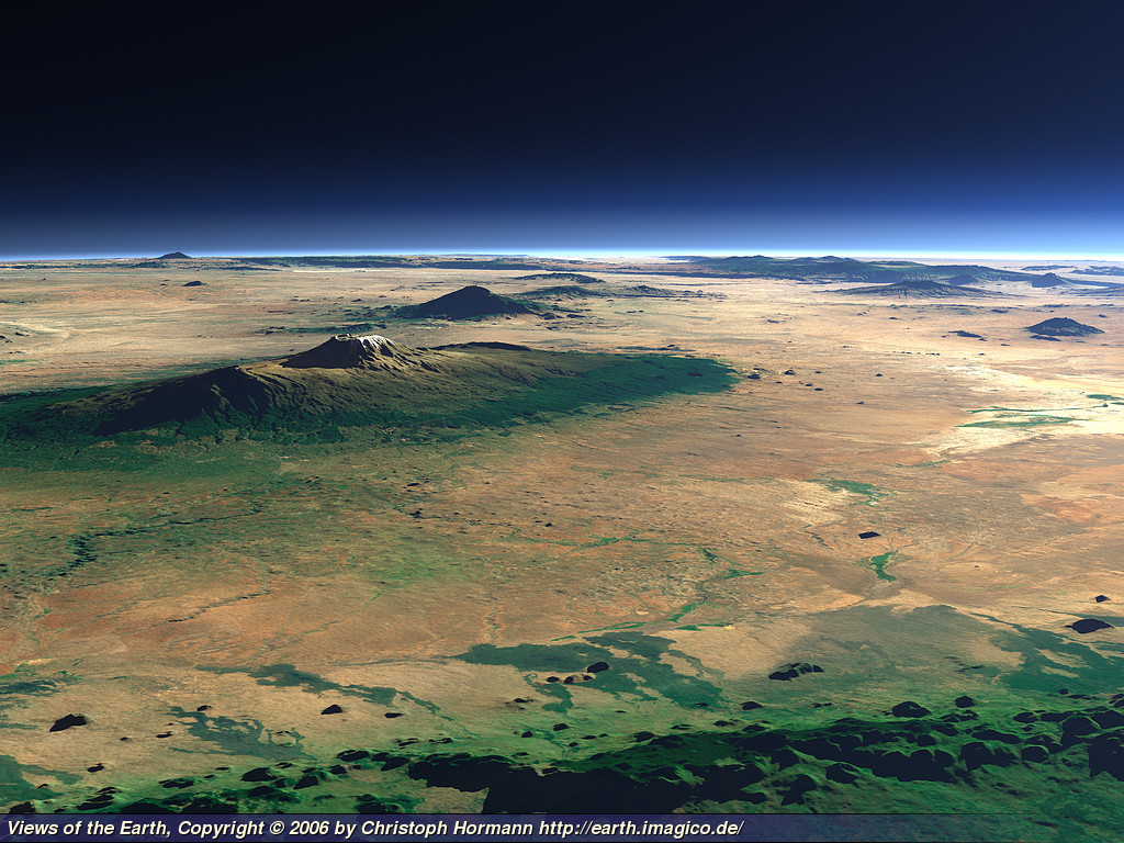
In and around the Rift Valley vicinity are the largest volcanoes in Africa and the world, including Mt. Kenya and Mt. Kilimanjaro.
リフトバレー周辺には、ケニア山やキリマンジャロ山など、アフリカと世界で最大の火山があります。
〈http://www.mountkenyaexpeditions.com/images/mtkenyaclimb.jpg〉
〈http://earth.imagico.de/views/kilimanjaro2_large.jpg〉
Some are extinct and the majority have not erupted for hundreds of years.
いくつかは死火山に成っていて、大部分は何百年もの間噴火していません。
All of them represent what geologists call, "shield volcanoes" that occur over spots that are particularly hot, with magma unusually close to the surface.
それらはすべて、地質学者が「楯状火山」と呼んでいるものを表しており、マグマが異常に表面に近く、特に高温の場所に発生します。
〈https://kotobank.jp/word/%E6%A5%AF%E7%8A%B6%E7%81%AB%E5%B1%B1-93708〉
Mt. Kilimanjaro and the others are really multiple volcanoes that have merged together into larger structures.
キリマンジャロ山と他の火山は、実際には複数の火山であり、より大きな構造に統合されています。
There are very large fractures beneath the peaks from which the original eruptions took place, similar to the long fracture volcanoes in Hawaii.
ハワイの長い裂罅(れっか)火山と同様に、最初の噴火が起こった山頂の下には非常に大きな裂罅(れっか)があります。
Those African peaks include Mt. Kilimanjaro, Mt. Elgon, Mt. Meru and many others.
それらのアフリカの山頂には、キリマンジャロ山、エルゴン山、メルー山などがあります。
〈https://photojournal.jpl.nasa.gov/jpeg/PIA04958.jpg〉
〈https://epod.usra.edu/〉
They are all located on top of a dual-ridge fault that circles Lake Victoria.
それらはすべて、ビクトリア湖を囲む二重尾根断層の上にあります。
〈http://neuropolitics.org/GreatRiftValley.gif〉
One very interesting aspect of the fault is that it begins as a bifurcation in the Afar Depression, loops back on itself as the Western Rift Valley, forms Lake Victoria and then travels to the south, where Lake Malawi fills-in the huge crack.
断層の非常に興味深い側面の1つは、アファール窪地の分岐点として始まり、西リフトバレーとしてループバックし、ビクトリア湖を形成してから、マラウイ湖が埋め尽くす南に移動することです。
〈http://earth.imagico.de/views/ethiopia_large.jpg〉
〈http://earth.imagico.de/views/kenya_large.jpg〉
〈https://youtu.be/44EzcfpM5tk〉
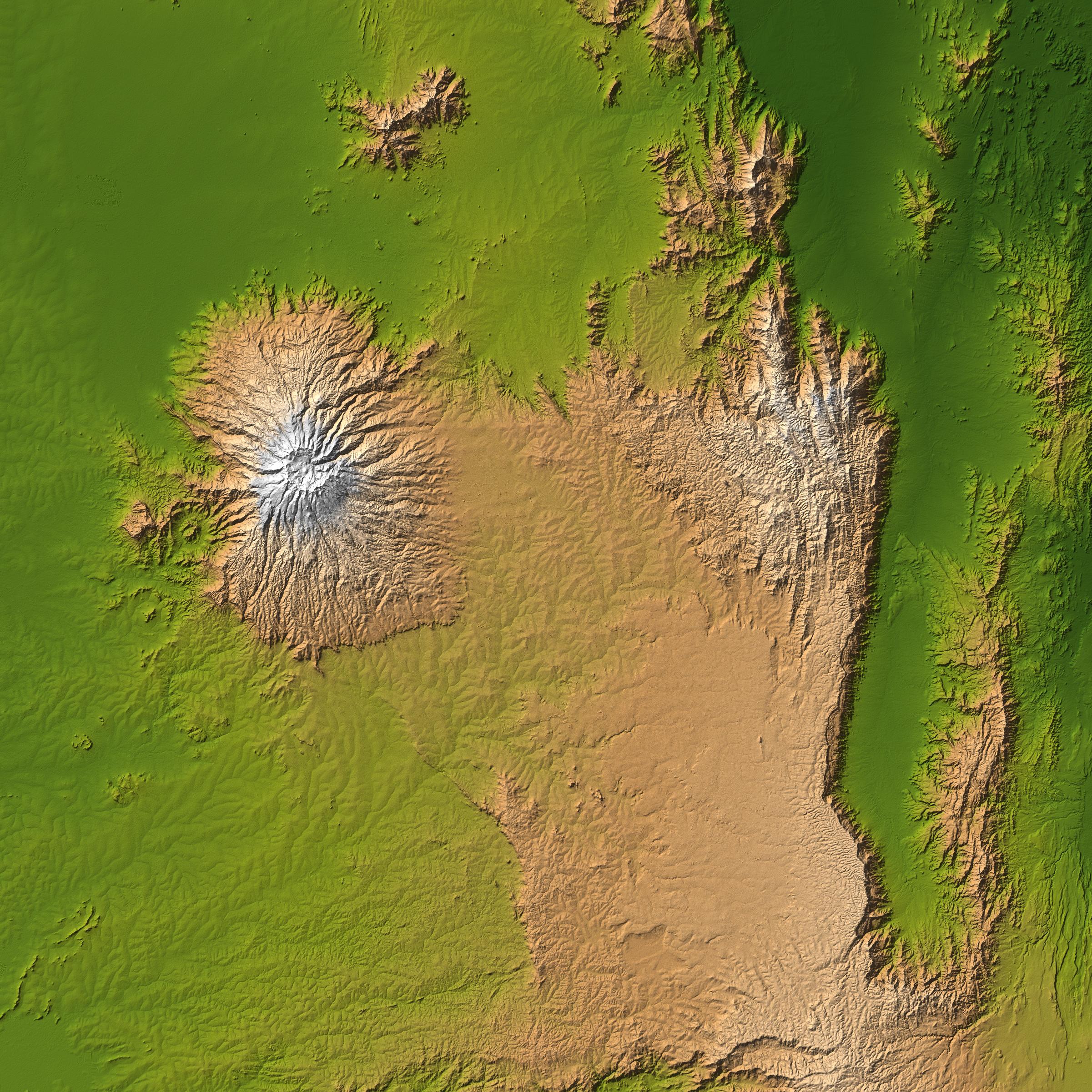
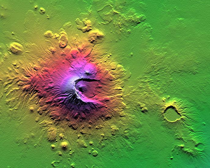
Near Mt. Meru are sharply cut dendritic ridge or "Lichtenberg" figures that cover hundreds of square miles.
メル山の近くには、数百平方マイルをカバーする鋭くカットされた樹枝状の尾根または「リッチェンバーグ(リヒテンベルク)」図形があります。
〈https://photojournal.jpl.nasa.gov/jpeg/PIA03356.jpg〉
Mt. Meru, itself is very unusual in that is a half crater with a sharply pointed central peak.
メル山自体は非常に珍しく、中央の山が鋭く尖った半火口(クレーター)です。
〈https://photojournal.jpl.nasa.gov/jpeg/PIA03358.jpg〉
In the Mountains of Patagonia article, such formations were presented as forming from large electric arc discharges, since no volcanic eruption would ever leave a needle-sharp peak in the blasted remains of a half-crater.
パタゴニア山脈の記事では、火山の噴火が半火口(クレーター)の爆破された残骸に針の鋭いピークを残すことは決してないので、そのような地層は大きな電気アーク放電からの地層として提示されました。
〈https://takaakifukatsu.hatenablog.jp/entry/2021/04/26/210618〉
Certainly Mt. St. Helens did not leave any such basalt monolith behind.
確かに、セントヘレンズ山はそのような玄武岩のモノリス(単岩)を残しませんでした。
Because Lake Victoria is a circular feature in the midst of a kilometer-deep trench, surrounded by the largest volcanoes in the world, with what appear to be city-wide lightning trackways carved into the rocks in many places.
ビクトリア湖は、世界最大の火山に囲まれた深さ1 kmの海溝の真ん中にある円形の特徴であり、多くの場所で岩に刻まれた都市規模の稲妻の道のように見えます。
It seems more reasonable to conclude that electrical forces created the Lake and the Rift Valley, just as they produced many other large circular features we have previously described.
電気力が湖と地溝帯を作り出したと結論付けるのは、以前に説明した他の多くの大きな円形の特徴を生み出したのと同じように、より合理的と思われます。
By Steve Smith
スティーブ・スミス