ザ・サンダーボルツ勝手連 [Southern Utah’s Catastrophic Past ユタ州南部の壊滅的な過去]
[Southern Utah’s Catastrophic Past ユタ州南部の壊滅的な過去]

Grosvenor Arch named for Gilbert Hovey Grosvenor
National Geographic Society president (1903-1954).
ギルバート・ホービー・グロブナーにちなんで名付けられたグロブナー・アーチ『ナショナルジオグラフィック協会会長(1903-1954)。』
―――――――
Feb 13, 2008
大階段-エスカランテ国定公園やその他の荒野の保護区は、巨大なスケールで放電加工の兆候を明らかにしています。
地球の地質学的特徴に関する継続的な調査では、考慮すべき最も重要な地域の1つが、コロラド、ユタ、ニューメキシコ、アリゾナの国境が接するフォーコーナーズ地域であることがわかりました。
〈https://www.visitutah.com/places-to-go/parks-outdoors/four-corners-area〉
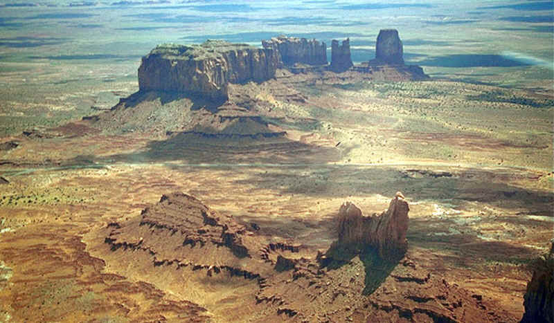
前回のサンダーボルトの今日の写真の記事で、アリゾナ州モニュメントバレーの巨大な砂岩のtors(岩山)を通過する際に言及しました。
〈https://takaakifukatsu.hatenablog.jp/entry/2021/04/25/093531〉
このようなモノリシック構造は数百万年前のものと言われ、風雨による侵食の結果であると一般に考えられています。
しかしながら、そのような理論には困難があります
–少なくとも、層状の地層は、関係する岩石の硬度や浸透性に関係なく、均一に刻まれています。
巨大なビュートとバットレスの輪郭は、何百マイルもの間に亘って、風景の中を蛇行する曲線を描くように常に形作られています。
〈http://www.nationalgeographic.org/encyclopedia/butte/〉
〈https://eow.alc.co.jp/search?q=buttress〉
〈http://www.detectingdesign.com/images/Geology/MonumentValley2.jpg〉
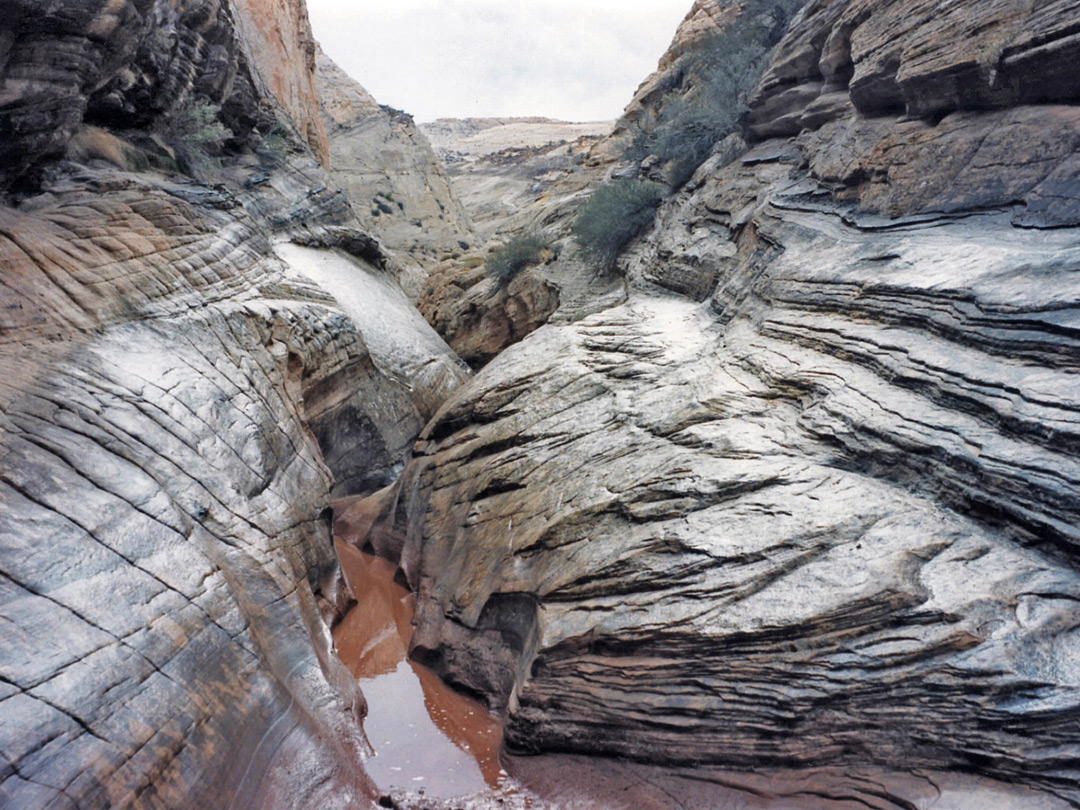
点在する垂直の尾根(ほとんどの場合、基部は30度の「肩」で囲まれています)は、古代の円錐形の通気孔と、岩壁にテラスと薄い割れ目を含む深い峡谷です。
〈https://www.americansouthwest.net/slot_canyons/photographs700/burro4.jpg〉
キャニオンデシェイ地域で見られる地層は、火星の地理をいくらか思い出させます。
〈https://commons.wikimedia.org/wiki/File:Canyon_de_Chelly,_Navajo.jpg〉
〈https://mars.nasa.gov/mgs/msss/camera/images/10_30_01_releases/schiaparelli/E03-00728_sub100.gif〉
大階段-エスカランテ国定公園とキャピトルリーフ国立公園は、地上の天候の力では簡単に説明できない石のモノリス、谷、アーチ、崖の注目すべき例を提供します。
火星の姿は私たちが地球上で見つけたものに似ており、火星には実質的に大気も水もないので、両方の惑星の風景に見られる形をどのような力で形作ることができますか?
ドームやその他の隆起した地形は、地球上の多くの場所で見つけることができます。
ブラントベルク山塊は、平らな地形から立ち上がる巨大な石塚の一例で、切り込みの入った縞模様と岩の表土に焼き付いたリッチェンバーグ(リヒテンベルク)図形に囲まれています。
〈http://www.thunderbolts.info/tpod/2007/arch07/070625brandbergmassif.htm〉
グランド階段 - エスカランテでは、ナバホ砂岩のドームのように、巨大な山塊に近い親戚がいます。
〈https://scenicusa.net/071913.html〉
ユタ州のナバホ山脈に位置し、公園の近くにある、それはそこにある多くのユニークな特徴の1つにすぎません。
〈https://en.wikipedia.org/wiki/Navajo_Mountain〉
120メートルの丸みを帯びた固い岩の塚には、明るいオレンジ色の砂で満たされた深さ35メートルの円形のポケットがあります。
くぼみの中心から12メートルの白い砂岩の柱が立ち上がっています。
また、ローカルな環境には、キャピトルリーフ国立公園の名前が付けられた「礁(しょう)」もあります。
〈http://www.cpluhna.nau.edu/Places/landforms_reefs.htm〉
これらの曲線のデュアルリッジ構造は、バージニア州のマッサヌッテン山地、またはイランのザグロス山脈に匹敵します。
〈https://photojournal.jpl.nasa.gov/jpeg/PIA03382.jpg〉
〈http://thunderbolts.info/tpod/2007/arch07/071001zagrosmountains.htm〉
また、同様の方法で中央の複合施設から一掃する「溶岩岩脈」がニューメキシコ州シップロックを取り囲んでいることにも注目しました。
〈http://thunderbolts.info/tpod/2007/arch07/070813shiprock.htm〉
奇妙な地形の多くの例は、数十の記事を記述するだけで列挙することができます。
小さなサンプルには次のものが含まれます:
• The Temples of the Sun and Moon〈https://www.largeformatphotography.info/qtluong/capitol-temple.big.jpeg〉
• Chimney Rock〈https://www.bing.com/images/search?view=detailV2&ccid=DDuQaeSm&id=058F969E95B03C05CB10D5826C2BFB5215EC34A0&thid=OIP.DDuQaeSm-3Ku1cYr5BFamgHaE9&mediaurl=https%3A%2F%2Fvisitnebraska.com%2Fsites%2Fdefault%2Ffiles%2Flisting_images%2Fprofile%2F3399%2FChimneyRock_709_10jpg1488325619.jpg&exph=1286&expw=1920&q=chimney+rock&simid=607991765175465794&ck=AD5470765AE7BA09E09BA2E36B09322C&selectedindex=0&form=IRPRST&ajaxhist=0&vt=4&sim=11〉
• Cobra Arch〈https://parkerlab.bio.uci.edu/pictures/photography%20pictures/Cobra%20Ach.jpg〉
• Cathedral Valley〈https://www.earthtrekkers.com/cathedral-valley-loop/〉
• Toadstool Hoodoo〈https://parkerlab.bio.uci.edu/pictures/photography%20pictures/Toadstool%20hoodoo.jpg〉
• The Wave〈https://storyweb.jp/digitalist/131236/〉
「それらは、明白な分析を行うには、非常に珍しい心が必要です。」
スティーブン・スミス著
―――――――
Feb 13, 2008
Grand Staircase-Escalante National Monument and other wilderness preserves reveal the signs of electric discharge machining on an immense scale.
大階段-エスカランテ国定公園やその他の荒野の保護区は、巨大なスケールで放電加工の兆候を明らかにしています。
In our continuing investigation into the geological features of planet Earth, we find that one of the most important regions to consider is the Four Corners area where the borders of Colorado, Utah, New Mexico and Arizona meet.
地球の地質学的特徴に関する継続的な調査では、考慮すべき最も重要な地域の1つが、コロラド、ユタ、ニューメキシコ、アリゾナの国境が接するフォーコーナーズ地域であることがわかりました。
〈https://www.visitutah.com/places-to-go/parks-outdoors/four-corners-area〉
In a previous Thunderbolts Picture of the Day article we mentioned in passing the giant sandstone tors of Monument Valley, Arizona.
前回のサンダーボルトの今日の写真の記事で、アリゾナ州モニュメントバレーの巨大な砂岩のtors(岩山)を通過する際に言及しました。
〈https://takaakifukatsu.hatenablog.jp/entry/2021/04/25/093531〉
Such monolithic structures are said to be millions of years old and are commonly thought to be the result of erosion from wind and rain.
このようなモノリシック構造は数百万年前のものと言われ、風雨による侵食の結果であると一般に考えられています。
There are difficulties with such a theory, however
– not the least of which is that the layered strata are uniformly carved without regard to the hardness or the permeability of the rocks involved.
しかしながら、そのような理論には困難があります
–少なくとも、層状の地層は、関係する岩石の硬度や浸透性に関係なく、均一に刻まれています。
The contours of the gigantic buttes and buttresses are invariably shaped in sweeping curves that meander through the landscape for hundreds of miles.
巨大なビュートとバットレスの輪郭は、何百マイルもの間に亘って、風景の中を蛇行する曲線を描くように常に形作られています。
〈http://www.nationalgeographic.org/encyclopedia/butte/〉
〈https://eow.alc.co.jp/search?q=buttress〉
〈http://www.detectingdesign.com/images/Geology/MonumentValley2.jpg〉
Interspersed with the vertical ridges (most with their bases surrounded by thirty-degree “shoulders”) are ancient cone-shaped vents and deep canyons containing terraces and thin fractures in the rockface.
点在する垂直の尾根(ほとんどの場合、基部は30度の「肩」で囲まれています)は、古代の円錐形の通気孔と、岩壁にテラスと薄い割れ目を含む深い峡谷です。
〈https://www.americansouthwest.net/slot_canyons/photographs700/burro4.jpg〉
The formations, particularly those found in the Canyon de Chelly region, are somewhat reminiscent of Martian geography.
キャニオンデシェイ地域で見られる地層は、火星の地理をいくらか思い出させます。
〈https://commons.wikimedia.org/wiki/File:Canyon_de_Chelly,_Navajo.jpg〉
〈https://mars.nasa.gov/mgs/msss/camera/images/10_30_01_releases/schiaparelli/E03-00728_sub100.gif〉
Grand Staircase-Escalante National Monument and the Capitol Reef National Park provide remarkable examples of stone monoliths, valleys, arches and cliffs that cannot be easily explained by the terrestrial forces of weather.
大階段-エスカランテ国定公園とキャピトルリーフ国立公園は、地上の天候の力では簡単に説明できない石のモノリス、谷、アーチ、崖の注目すべき例を提供します。
Because figures on Mars resemble those we find here on Earth, and Mars has virtually no atmosphere and no water, what force can sculpt the shapes we find in the landscape of both planets?
火星の姿は私たちが地球上で見つけたものに似ており、火星には実質的に大気も水もないので、両方の惑星の風景に見られる形をどのような力で形作ることができますか?
Domes and other uplifted terrain can be found in many places on Earth.
ドームやその他の隆起した地形は、地球上の多くの場所で見つけることができます。
The Brandberg Massif is one example of a gigantic stone mound that rises out of flat topography, surrounded by incised striations and Lichtenberg figures burned into the rocky overburden.
ブラントベルク山塊は、平らな地形から立ち上がる巨大な石塚の一例で、切り込みの入った縞模様と岩の表土に焼き付いたリッチェンバーグ(リヒテンベルク)図形に囲まれています。
〈http://www.thunderbolts.info/tpod/2007/arch07/070625brandbergmassif.htm〉
In Grand Staircase-Escalante there are smaller relatives to the gigantic Massif, like Navajo Sandstone Dome.
グランド階段 - エスカランテでは、ナバホ砂岩のドームのように、巨大な山塊に近い親戚がいます。
〈https://scenicusa.net/071913.html〉
Situated in the Navajo Mountains of Utah, near the park, it is only one of many unique features found there.
ユタ州のナバホ山脈に位置し、公園の近くにある、それはそこにある多くのユニークな特徴の1つにすぎません。
〈https://en.wikipedia.org/wiki/Navajo_Mountain〉
The 120-meter rounded mound of solid rock is crowned with a 35-meter-deep, circular pocket filled with bright orange sand.
120メートルの丸みを帯びた固い岩の塚には、明るいオレンジ色の砂で満たされた深さ35メートルの円形のポケットがあります。
From the center of the depression rises a 12-meter column of white sandstone.
くぼみの中心から12メートルの白い砂岩の柱が立ち上がっています。
Also found in the local environs are the “reefs” for which Capitol Reef National Park is named.
また、ローカルな環境には、キャピトルリーフ国立公園の名前が付けられた「礁(しょう)」もあります。
〈http://www.cpluhna.nau.edu/Places/landforms_reefs.htm〉
These curvilinear, dual-ridge structures are comparable to those in the Massanutten Mountains of Virginia, or the Zagros Mountains, Iran.
これらの曲線のデュアルリッジ構造は、バージニア州のマッサヌッテン山地、またはイランのザグロス山脈に匹敵します。
〈https://photojournal.jpl.nasa.gov/jpeg/PIA03382.jpg〉
〈http://thunderbolts.info/tpod/2007/arch07/071001zagrosmountains.htm〉
We have also noted that “lava dikes” that sweep away from the central complex in similar fashion surround Shiprock, New Mexico.
また、同様の方法で中央の複合施設から一掃する「溶岩岩脈」がニューメキシコ州シップロックを取り囲んでいることにも注目しました。
〈http://thunderbolts.info/tpod/2007/arch07/070813shiprock.htm〉
So many examples of bizarre landforms could be listed that it would require dozens of articles just to describe them.
奇妙な地形の多くの例は、数十の記事を記述するだけで列挙することができます。
A small sample includes:
小さなサンプルには次のものが含まれます:
• The Temples of the Sun and Moon〈https://www.largeformatphotography.info/qtluong/capitol-temple.big.jpeg〉
• Chimney Rock〈https://www.bing.com/images/search?view=detailV2&ccid=DDuQaeSm&id=058F969E95B03C05CB10D5826C2BFB5215EC34A0&thid=OIP.DDuQaeSm-3Ku1cYr5BFamgHaE9&mediaurl=https%3A%2F%2Fvisitnebraska.com%2Fsites%2Fdefault%2Ffiles%2Flisting_images%2Fprofile%2F3399%2FChimneyRock_709_10jpg1488325619.jpg&exph=1286&expw=1920&q=chimney+rock&simid=607991765175465794&ck=AD5470765AE7BA09E09BA2E36B09322C&selectedindex=0&form=IRPRST&ajaxhist=0&vt=4&sim=11〉
• Cobra Arch〈https://parkerlab.bio.uci.edu/pictures/photography%20pictures/Cobra%20Ach.jpg〉
• Cathedral Valley〈https://www.earthtrekkers.com/cathedral-valley-loop/〉
• Toadstool Hoodoo〈https://parkerlab.bio.uci.edu/pictures/photography%20pictures/Toadstool%20hoodoo.jpg〉
• The Wave〈https://storyweb.jp/digitalist/131236/〉
"It requires a very unusual mind to undertake the analysis of the obvious."
-
-
- Alfred North Whitehead
-
「それらは、明白な分析を行うには、非常に珍しい心が必要です。」
By Stephen Smith
スティーブン・スミス著