[The Norwegian Fjords ノルウェーのフィヨルド]
Stephen Smith August 6, 2013Picture of the Day

The Scandinavian Peninsula from space.
宇宙からのスカンジナビア半島。
――――――――
Aug 07, 2013
ノルウェーの海岸に巨大な塹壕を切り込んだのは何ですか?
北スカンジナビアはおそらく地球上で最も険しい地形です。
それは2000キロメートルにわたってアジア大陸から外側に伸びる半島の陸塊であり、その北西の端に刻まれた膨大な数の深いフィヨルドで有名です。
いくつかの割れ目は、高さ1000メートルの崖の壁に深さ800メートルで陥入します。
多くは100キロメートル以上の長さです
–ソグネ・フィヨルデンは204キロメートルで最も長いです。
〈https://ja.wikipedia.org/wiki/%E3%82%BD%E3%82%B0%E3%83%8D%E3%83%BB%E3%83%95%E3%82%A3%E3%83%A8%E3%83%AB%E3%83%89〉
いくつかの場所では、それは同じ高さの周囲の山々と共に1300メートル以上の深さです。
プレーケストーレン(「パルピットロック」)の見落としているものは、おそらくヨセミテ国立公園の形成を除いて、比類のない壮大な景色を提供します。
〈https://townsofusa.com/travels/wp-content/uploads/2013/05/6512_Preikestolen_1024.jpg〉
プレーケストーレンは、乾燥した風景ではなく、600メートルから深く澄んだ水を見下ろしています。
構造は偉大なモノリス、エルキャピタンに似ています
―周囲の地形の下または覆っている岩の破片が(あるとしても)ほとんどない垂直花崗岩の壁です。
ほとんどの地質学者達はフィヨルドが氷河起源であると考えているため、氷が入り江を切り、前進する前に物質を「ブルドーザー」で覆い、最終的には海に投棄すると理論づけられています。
従来の理解によれば、フィヨルドは氷河前の谷の位置によって形作られる可能性があります。
氷の流れは抵抗が最も少ない経路を探す傾向があるため、それらが刻まれている岩盤の全体的な性質、または地球の地殻の割れ目や断層も、それらの形成に寄与している可能性があります。
多くの場合、水路の近くの両側の谷底は平らです。
海の入り口は小さな島々が集まった浅瀬にあります。
最も深い部分は通常、フィヨルドの口から遠く離れた場所にあり、地質学者が主張するように、かつて谷を埋めていた氷河が地球により深く刻まれています。
ノルウェーの西海岸の興味深い側面は、フィヨルドを宇宙から見ると、数え切れないほどの、複数の枝分かれしたリッチェンバーグ(リヒテンベルク)図形に他ならないように見えることです。
〈http://www.esa.int/ESA_Multimedia/Images/2010/06/Fjords_and_islands_in_Norway〉
ページ上部の画像では、何千ものフィヨルドがフィリグリーとして表示されており、細線細工が細かく分割されています、これは、稲妻タイプの放電の特徴です。
それらの放電は想像を絶するほど強力だったに違いありません。
それらは、逆を除いて、海岸の切り込みのある形を反映する山脈と内陸の頂上によって東に一致しています:
それらは風景に浮き彫りにされています。
火星の異常な地形に関するサンダーボルツ 「今日の写真」の記事では、そのような属性は「樹状突起の尾根」として識別されました
–オリンパスモンスの斜面を打つ巨大なプラズマ電光によって引き起こされるトラックウェイです。
スカンジナビアとのさらなる比較を懇願する別の地域は、ロシアのシベリアトラップとプトラナ台地で、ノルウェー西部に切り込んだ同じ種類のリッチェンバーグ(リヒテンベルク)図形が支配する約60万平方キロメートルの地域です。
それらは関連していますか?
同じプロセスで両方の地形を作成できたでしょうか?
電気的宇宙の仮説を支持する1つの興味深い事実は、グリーンランド東部では、ノルウェーと同じように何千ものフィヨルドが見られます。
〈https://earthobservatory.nasa.gov/images/7878/summer-thaw-eastern-greenland〉
まるで途方もない力が地球の高緯度をつかみ、強力な垂直電場で表面から粉砕された石の塊を破壊したように見えます。
多様な兆ジュールの範囲の電気の移動電流と相まって、地下の物質は文字通り宇宙に爆発したり、数千キロメートルにわたって風に投げ込まれたりして、今日の地理になりました。
地球が大陸を再形成し、おそらくこの惑星の人間の記憶の中に大西洋盆地を開いた大災害が地球を訪れたという私たちの主張には、ほとんど信じられないほどの証拠が残っています。
スカンジナビア半島は、らせん状プラズマビームの化石化した渦である可能性があります、それは世界を変えるのに十分強力な電気の火の雲の中にシベリア、フィンランド、ノルウェー、スウェーデンそして他の場所を飲み込みました。
以前の「今日の写真」の記事では、火星の極渦は、赤い惑星にほぼ同じダメージを与えたプラズマビームの残骸であると推定されました。
〈http://www.thunderbolts.info/tpod/2007/arch07/071227polarvortices.htm〉
北の緯度は単に一掃され、惑星の平均標高より何キロも下に爆破された荒廃だけが残りました。
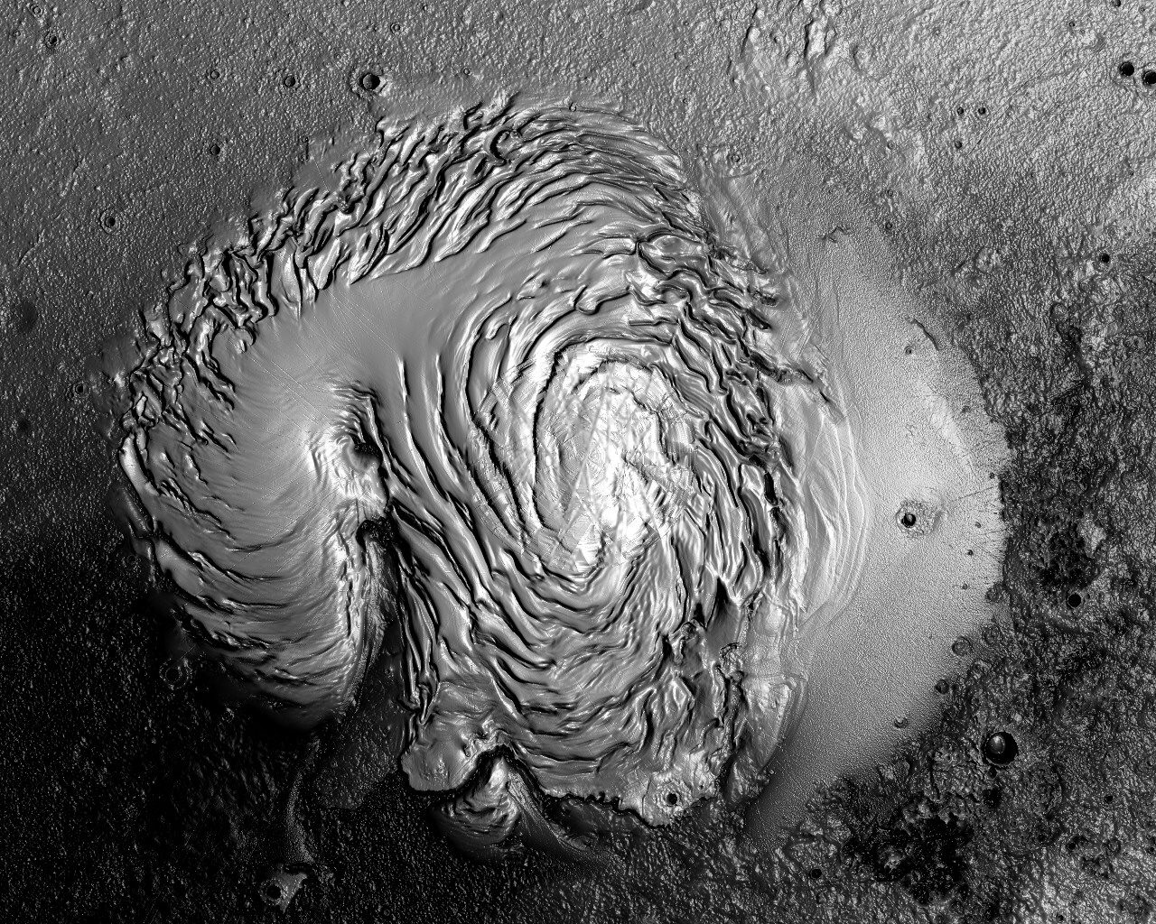
スカンジナビアと火星の北極点を並べた比較は、啓示的です。
〈http://mars3d.com/Gallery/NorthPoleBW-1280x1024.JPG〉
スティーブン・スミス
――――――――
Aug 07, 2013
What cut the colossal trenches into the coast of Norway?
ノルウェーの海岸に巨大な塹壕を切り込んだのは何ですか?
Northern Scandinavia is probably the most rugged terrain on Earth.
北スカンジナビアはおそらく地球上で最も険しい地形です。
It is a peninsular landmass extending outward from the Asian continent for 2000 2kilometers and is notable for the enormous number of deep fjords carved into its northwestern edge.
それは2000キロメートルにわたってアジア大陸から外側に伸びる半島の陸塊であり、その北西の端に刻まれた膨大な数の深いフィヨルドで有名です。
Some of the chasms plunge 800 meters deep with cliff walls 1000 meters high.
いくつかの割れ目は、高さ1000メートルの崖の壁に深さ800メートルで陥入します。
Many are more than 100 kilometers long – Sognefjorden being the longest at 204 kilometers.
多くは100キロメートル以上の長さです
–ソグネ・フィヨルデンは204キロメートルで最も長いです。
〈https://ja.wikipedia.org/wiki/%E3%82%BD%E3%82%B0%E3%83%8D%E3%83%BB%E3%83%95%E3%82%A3%E3%83%A8%E3%83%AB%E3%83%89〉
In some places, it is more than 1300 meters deep with surrounding mountains of equal height.
いくつかの場所では、それは同じ高さの周囲の山々と共に1300メートル以上の深さです。
Preikestolen (“Pulpit Rock”) overlook provides a spectacular scenic view that is unrivaled, except, perhaps by the Yosemite National Park formations.
プレーケストーレン(「パルピットロック」)の見落としているものは、おそらくヨセミテ国立公園の形成を除いて、比類のない壮大な景色を提供します。
〈https://townsofusa.com/travels/wp-content/uploads/2013/05/6512_Preikestolen_1024.jpg〉
Preikestolen looks down from 600 meters on deep, clear water, however, rather than a dry landscape.
プレーケストーレンは、乾燥した風景ではなく、600メートルから深く澄んだ水を見下ろしています。
It is similar in structure to the great monolith, El Capitan
– a vertical granite wall with little (if any) rock debris below or covering the surrounding terrain.
構造は偉大なモノリス、エルキャピタンに似ています
–周囲の地形の下または覆っている岩の破片が(あるとしても)ほとんどない垂直花崗岩の壁です。
Because most geologists consider the fjords to be glacial in origin, it is theorized that the ice cut the inlets and then “bulldozed” the material ahead of their advance, eventually dumping it into the ocean.
ほとんどの地質学者達はフィヨルドが氷河起源であると考えているため、氷が入り江を切り、前進する前に物質を「ブルドーザー」で覆い、最終的には海に投棄すると理論づけられています。
According to conventional understanding, fjords may be shaped by their locations in pre-glacial valleys.
従来の理解によれば、フィヨルドは氷河前の谷の位置によって形作られる可能性があります。
The overall nature of the bedrock into which they are carved or fissures and faults in the Earth’s crust might also have contributed to their formation since ice flows tend to seek the path of least resistance.
氷の流れは抵抗が最も少ない経路を探す傾向があるため、それらが刻まれている岩盤の全体的な性質、または地球の地殻の割れ目や断層も、それらの形成に寄与している可能性があります。
Often, the valley floors on either side, near the channels, are flat.
多くの場合、水路の近くの両側の谷底は平らです。
The sea entrances are in shallow water populated by small islands.
海の入り口は小さな島々が集まった浅瀬にあります。
The deepest portions are usually located far from the mouth of the fjord where, as geologists posit, the glaciers that once filled the valleys carved more deeply into the Earth.
最も深い部分は通常、フィヨルドの口から遠く離れた場所にあり、地質学者が主張するように、かつて谷を埋めていた氷河が地球により深く刻まれています。
An intriguing aspect to the western coast of Norway is that the fjords, when viewed from space, look like nothing less than innumerable, multiply brachiated Lichtenberg figures.
ノルウェーの西海岸の興味深い側面は、フィヨルドを宇宙から見ると、数え切れないほどの、複数の枝分かれしたリッチェンバーグ(リヒテンベルク)図形に他ならないように見えることです。
〈http://www.esa.int/ESA_Multimedia/Images/2010/06/Fjords_and_islands_in_Norway〉
In the image at the top of the page, thousands of fjords are visible as a filigree that divides into finer and finer detail, a signature of lightning-type discharges.
ページ上部の画像では、何千ものフィヨルドがフィリグリーとして表示されており、細線細工が細かく分割されています、これは、稲妻タイプの放電の特徴です。
Those discharges must have been unimaginably powerful.
それらの放電は想像を絶するほど強力だったに違いありません。
They are matched to the east by mountain ranges and inland peaks that reflect the incised forms on the coast, except in reverse:
they are embossed upon the landscape.
それらは、逆を除いて、海岸の切り込みのある形を反映する山脈と内陸の頂上によって東に一致しています:
それらは風景に浮き彫りにされています。
In our Thunderbolts Picture of the Day article about anomalous terrain on Mars, such attributes were identified as “dendritic ridges”
– trackways caused by gigantic plasma bolts striking the slopes of Olympus Mons.
火星の異常な地形に関するサンダーボルツ 「今日の写真」の記事では、そのような属性は「樹状突起の尾根」として識別されました
–オリンパスモンスの斜面を打つ巨大なプラズマ電光によって引き起こされるトラックウェイです。
Another region that begs further comparison with Scandinavia is the Siberian Traps and the Putorana Plateau in Russia, an area of some 600,000 square kilometers dominated by the same kind of Lichtenberg figures that cut into western Norway.
スカンジナビアとのさらなる比較を懇願する別の地域は、ロシアのシベリアトラップとプトラナ台地で、ノルウェー西部に切り込んだ同じ種類のリッチェンバーグ(リヒテンベルク)図形が支配する約60万平方キロメートルの地域です。
Are they related?
それらは関連していますか?
Could the same process have created both topographies?
同じプロセスで両方の地形を作成できたでしょうか?
One interesting fact that supports the Electric Universe hypothesis is that eastern Greenland reveals thousands of fjords just like those in Norway.
電気的宇宙の仮説を支持する1つの興味深い事実は、グリーンランド東部では、ノルウェーと同じように何千ものフィヨルドが見られます。
〈https://earthobservatory.nasa.gov/images/7878/summer-thaw-eastern-greenland〉
It appears as if tremendous forces gripped the high latitudes of Earth and wrenched pulverized masses of stone out of the surface in powerful, vertical electric fields.
まるで途方もない力が地球の高緯度をつかみ、強力な垂直電場で表面から粉砕された石の塊を破壊したように見えます。
Coupled with traveling currents of electricity in the manifold trillion-joule range, the subsurface materials were literally exploded into space or thrown to the winds for thousands of kilometers, resulting in today’s geography.
多様な兆ジュールの範囲の電気の移動電流と相まって、地下の物質は文字通り宇宙に爆発したり、数千キロメートルにわたって風に投げ込まれたりして、今日の地理になりました。
An almost unbelievable piece of evidence remains for our contention that Earth has been visited by catastrophes that reshaped its continents and, perhaps, opened the Atlantic Ocean basin within the memory of human beings on this planet.
地球が大陸を再形成し、おそらくこの惑星の人間の記憶の中に大西洋盆地を開いた大災害が地球を訪れたという私たちの主張には、ほとんど信じられないほどの証拠が残っています。
The Scandinavian Peninsula may be the fossilized vortex of a helical plasma beam that engulfed Siberia, Finland, Norway, Sweden and other locations in a cloud of electric fire powerful enough to change the world.
スカンジナビア半島は、らせん状プラズマビームの化石化した渦である可能性があります、それは世界を変えるのに十分強力な電気の火の雲の中にシベリア、フィンランド、ノルウェー、スウェーデンそして他の場所を飲み込みました。
In a previous Picture of the Day article, polar vortices on Mars were presumed to be the remains of plasma beams that did nearly identical damage to the Red Planet.
以前の「今日の写真」の記事では、火星の極渦は、赤い惑星にほぼ同じダメージを与えたプラズマビームの残骸であると推定されました。
〈http://www.thunderbolts.info/tpod/2007/arch07/071227polarvortices.htm〉
The northern latitudes were simply wiped away, leaving nothing but a blasted desolation many kilometers below the mean elevation of the planet.
北の緯度は単に一掃され、惑星の平均標高より何キロも下に爆破された荒廃だけが残りました。
A side-by-side comparison of Scandinavia and the North Pole on Mars is revelatory.
スカンジナビアと火星の北極点を並べた比較は、啓示的です。
〈http://mars3d.com/Gallery/NorthPoleBW-1280x1024.JPG〉
Stephen Smith
スティーブン・スミス